|
|
|
Specific Water Well Detail |
|
|
| Location Info | |||
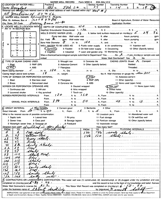
| Owner: Keen, Houston E. | Status: Constructed | ||
| Location: T14S, R19E, Sec. 35, SW SW SW | County: Douglas | ||
| Directions: 59 and 56 Jct | |||
| Latitude: 38.7831866 | Longitude: -95.2775561 | Datum NAD 27 | |
| Latitude: 38.783193 | Longitude: -95.2778077 | Datum NAD 83 | |
| Longitude and latitude calculated by Survey from township-range-section-quarter calls. Only good to within the quarter call accuracy. | |||
| View well on interactive map | |||
| General Info | ||
| Well Depth: 150 ft. | Elevation: ft. | |
| Static Water Level: 72 ft. | Est. Yield: 2 gpm. | |
| Comp. Date: 29-May-1996 | Well Use: Domestic | |
| DWR Applic. #: | Other ID: | |
| Driller Info | ||
| Driller: Kenneth Schutz Drilling | License #: 212 | |
| Scanned Form | View scan |
|
Chemical Sample Submitted?: No
Water Well disinfected?: | ||
| Ground water encountered: 132 ft. , 0 ft. , 0 ft. | ||
| Pump test data: Well water was 0 ft after 0 hours pumping 0 gpm | ||
| Casing Info | ||
| Casing Type: PVC
Casing Joints: |
Diam: 5 in. to 130 ft
Diam: 0 in. to 0 ft Diam: 0 in. to 0 ft | |
| Casing height above land surface: in
Casing Weight: lbs/ft Wall thickness or gauge no.: | ||
| Screen and Perforation Info | ||
| Screen Type: PVC | Screen Openings: Saw cut | |
| Screen-perforated intervals | From: 130 ft to 150 ft
From: 0 ft to 0 ft From: 0 ft to 0 ft | |
| Gravel pack intervals | From: ft to ft | |
| Grout Info | ||
| Grout used: Neat cement | From: 50 to 40 ft
From: 15 to 5 ft From: 0 to 0 ft | |
| Source of Possible Contamination | ||
| Source: | ||
| Direction from well: | Distance: 0 ft | |
| Lithologic Log
(Log data entered by KGS.) | ||
| From: 0 ft. to 2 ft. | top soil | |
| From: 2 ft. to 23 ft. | yellow clay | |
| From: 23 ft. to 42 ft. | gray shale | |
| From: 42 ft. to 45 ft. | limestone | |
| From: 45 ft. to 52 ft. | sandy shale | |
| From: 52 ft. to 54 ft. | limestone | |
| From: 54 ft. to 93 ft. | shale | |
| From: 93 ft. to 104 ft. | shale, hard | |
| From: 104 ft. to 106 ft. | limestone | |
| From: 106 ft. to 115 ft. | shale | |
| From: 115 ft. to 117 ft. | limestone | |
| From: 117 ft. to 121 ft. | sandy shale | |
| From: 121 ft. to 123 ft. | limestone | |
| From: 123 ft. to 132 ft. | sandy shale | |
| From: 132 ft. to 140 ft. | sand | |
| From: 140 ft. to 146 ft. | sandy shale | |
| From: 146 ft. to 150 ft. | shale | |