|
|
|
Specific Water Well Detail |
|
|
| Location Info | |||
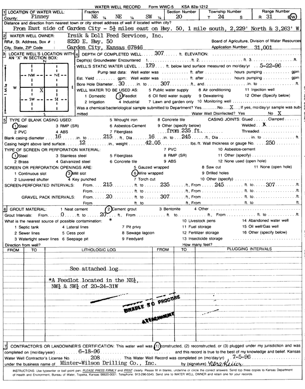
| Owner: Irsik and Doll Feedyard | Status: Constructed | ||
| Location: T24S, R31W, Sec. 20, NE NE SW | County: Finney | ||
| Directions: from E side of Garden City: 5.5 mi E on Hwy 50, 1 mi S, 2229 feet N, and 3263 feet W | |||
| Latitude: 37.9517305 | Longitude: -100.7476147 | Datum NAD 27 | |
| Latitude: 37.9517527 | Longitude: -100.7480496 | Datum NAD 83 | |
| Longitude and latitude calculated by Survey from township-range-section-quarter calls. Only good to within the quarter call accuracy. | |||
| View well on interactive map | |||
| General Info | ||
| Well Depth: 307 ft. | Elevation: ft. | |
| Static Water Level: 179 ft. | Est. Yield: gpm. | |
| Comp. Date: 18-Jun-1996 | Well Use: Feedlot | |
| DWR Applic. #: 31001 | Other ID: | |
| Links | |
| No Wizard information available. | |
| View info from WIMAS Water Right Data base... | |
| Driller Info | ||
| Driller: Minter-Wilson Drlg. Co., Inc. | License #: 208 | |
| Scanned Form | View scan |
|
Chemical Sample Submitted?: No
Water Well disinfected?: | ||
| Ground water encountered: 0 ft. , 0 ft. , 0 ft. | ||
| Pump test data: Well water was 0 ft after 0 hours pumping 0 gpm | ||
| Casing Info | ||
| Casing Type: PVC
Casing Joints: |
Diam: 16 in. to 215 ft
Diam: 0 in. to 0 ft Diam: 0 in. to 0 ft | |
| Casing height above land surface: in
Casing Weight: lbs/ft Wall thickness or gauge no.: | ||
| Screen and Perforation Info | ||
| Screen Type: Steel | Screen Openings: Mill slot | |
| Screen-perforated intervals | From: 215 ft to 235 ft
From: 0 ft to 0 ft From: 0 ft to 0 ft | |
| Gravel pack intervals | From: ft to ft | |
| Grout Info | ||
| Grout used: Cement grout | From: 0 to 20 ft
From: 0 to 0 ft From: 0 to 0 ft | |
| Source of Possible Contamination | ||
| Source: | ||
| Direction from well: | Distance: 0 ft | |
| Lithologic Log
(log data not edited or checked by the KGS.) | ||
| From: 0 ft. to 1 ft. | Type: CLAY | |
| From: 1 ft. to 2 ft. | Type: FINE SAND | |
| From: 2 ft. to 3 ft. | Type: CLAY | |
| From: 3 ft. to 5 ft. | Type: FINE SAND | |
| From: 5 ft. to 45 ft. | Type: SANDY CLAY | |
| From: 45 ft. to 48 ft. | Type: SAND & GRAVEL | |
| From: 48 ft. to 53 ft. | Type: SANDSTONE | |
| From: 53 ft. to 58 ft. | Type: SAND & GRAVEL | |
| From: 58 ft. to 70 ft. | Type: CLAY | |
| From: 70 ft. to 114 ft. | Type: SAND & GRAVEL | |
| From: 114 ft. to 127 ft. | Type: SANDY CLAY | |
| From: 127 ft. to 136 ft. | Type: SAND & GRAVEL | |
| From: 136 ft. to 140 ft. | Type: SANDY CLAY | |
| From: 140 ft. to 163 ft. | Type: ROCK & CLAY | |
| From: 163 ft. to 165 ft. | Type: FINE SAND | |
| From: 165 ft. to 200 ft. | Type: ROCK & CLAY | |
| From: 200 ft. to 214 ft. | Type: SANDY CLAY | |
| From: 214 ft. to 232 ft. | Type: SAND & GRAVEL | |
| From: 232 ft. to 237 ft. | Type: CLAY | |
| From: 237 ft. to 245 ft. | Type: FINE SAND | |
| From: 245 ft. to 263 ft. | Type: ROCK & SAND | |
| From: 263 ft. to 267 ft. | Type: CLAY | |
| From: 267 ft. to 297 ft. | Type: SAND & GRAVEL | |
| From: 297 ft. to 308 ft. | Type: CLAY | |
| From: 308 ft. to 320 ft. | Type: SHALE | |