|
|
|
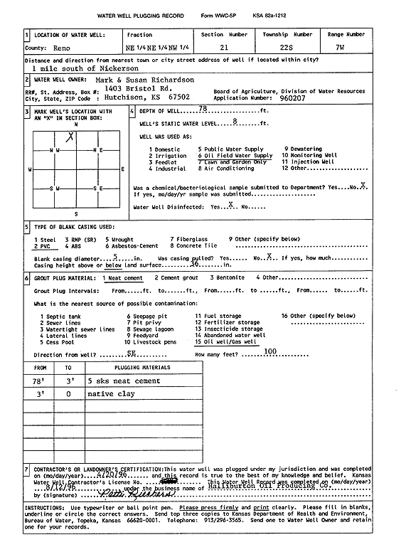
Specific Water Well Detail |
|
|
| Location Info | |||
| Owner: Richardson, Mark and Susan | Status: Plugged | ||
| Location: T22S, R7W, Sec. 21, NE NE NW | County: Reno | ||
| Directions: from Nickerson: 1 mi S | |||
| Latitude: 38.1292784 | Longitude: -98.0972817 | Datum NAD 27 | |
| Latitude: 38.1292898 | Longitude: -98.097617 | Datum NAD 83 | |
| Longitude and latitude calculated by Survey from township-range-section-quarter calls. Only good to within the quarter call accuracy. | |||
| View well on interactive map | |||
| General Info | ||
| Well Depth: 78 ft. | Elevation: ft. | |
| Static Water Level: 8 ft. | Est. Yield: gpm. | |
| Comp. Date: 20-Apr-1996 | Well Use: Oil Field Water Supply | |
| DWR Applic. #: 960207 | Other ID: Richardson SWD | |
| Driller Info | ||
| Driller: Halliburton Oil Producing Co. | License #: | |
| Scanned Form | View scan |
| Casing Info | ||
|
Casing Type: PVC
Diam: 5 in. Casing height above land surface: in | ||
| Grout Info | ||
| Grout used: Neat cement | From: 0 to 0 ft
From: 0 to 0 ft From: 0 to 0 ft | |
| Source of Possible Contamination | ||
| Source: Oil well/gas well | ||
| Direction from well: SE | Distance: 100 ft | |