|
|
|
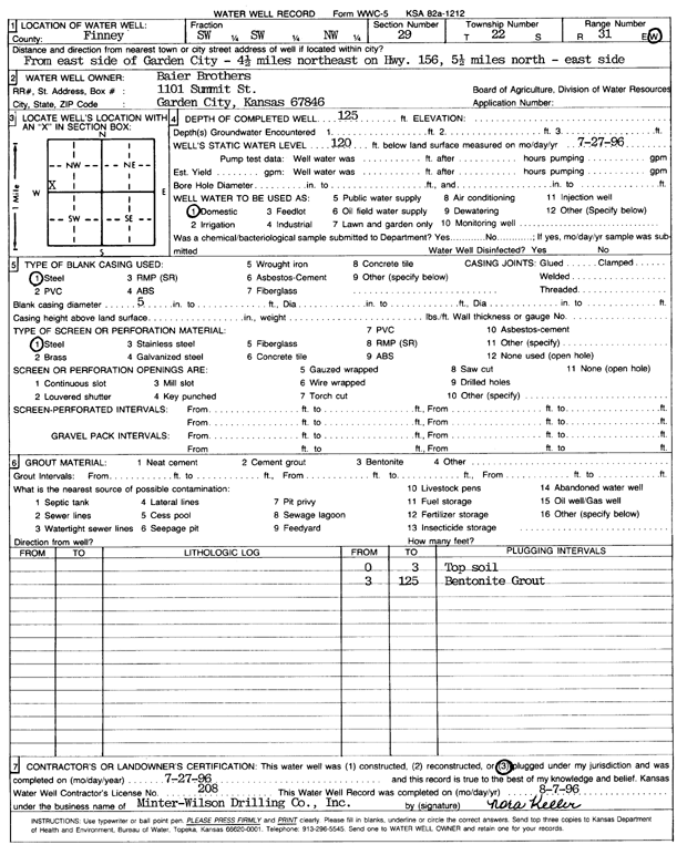
Specific Water Well Detail |
|
|
| Location Info | |||
| Owner: Baier Brothers | Status: Plugged | ||
| Location: T22S, R31W, Sec. 29, SW SW NW | County: Finney | ||
| Directions: from E side of Garden City: 4.5 mi NE on Hwy 156, 5.5 mi N, E side | |||
| Latitude: 38.1130179 | Longitude: -100.7543936 | Datum NAD 27 | |
| Latitude: 38.1130391 | Longitude: -100.7548263 | Datum NAD 83 | |
| Longitude and latitude calculated by Survey from township-range-section-quarter calls. Only good to within the quarter call accuracy. | |||
| View well on interactive map | |||
| General Info | ||
| Well Depth: 125 ft. | Elevation: ft. | |
| Static Water Level: 120 ft. | Est. Yield: gpm. | |
| Comp. Date: 27-Jul-1996 | Well Use: Domestic | |
| DWR Applic. #: | Other ID: | |
| Driller Info | ||
| Driller: MW Drilling | License #: 208 | |
| Scanned Form | View scan |
| Casing Info | ||
|
Casing Type: PVC
Diam: 5 in. Casing height above land surface: in | ||
| Grout Info | ||
| Grout used: Cement grout | From: 125 to 3 ft
From: 0 to 0 ft From: 0 to 0 ft | |
| Source of Possible Contamination | ||
| Source: | ||
| Direction from well: | Distance: 0 ft | |