|
|
|
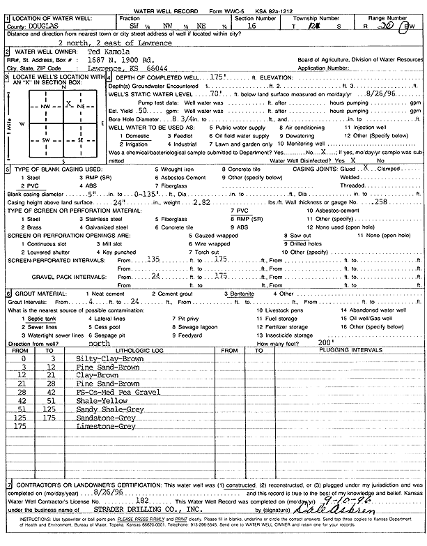
Specific Water Well Detail |
|
|
| Location Info | |||
| Owner: Kamola, Ted | Status: Constructed | ||
| Location: T12S, R20E, Sec. 16, SW NW NE | County: Douglas | ||
| Directions: from Lawrence: 2 mi N, 2 mi E | |||
| Latitude: 39.0123878 | Longitude: -95.1948366 | Datum NAD 27 | |
| Latitude: 39.0123895 | Longitude: -95.195086 | Datum NAD 83 | |
| Longitude and latitude calculated by Survey from township-range-section-quarter calls. Only good to within the quarter call accuracy. | |||
| View well on interactive map | |||
| General Info | ||
| Well Depth: 175 ft. | Elevation: ft. | |
| Static Water Level: 70 ft. | Est. Yield: 50 gpm. | |
| Comp. Date: 26-Aug-1996 | Well Use: Domestic | |
| DWR Applic. #: | Other ID: | |
| Driller Info | ||
| Driller: Strader Drilling Co., Inc. | License #: 182 | |
| Scanned Form | View scan |
|
Chemical Sample Submitted?: No
Water Well disinfected?: | ||
| Ground water encountered: 0 ft. , 0 ft. , 0 ft. | ||
| Pump test data: Well water was 0 ft after 0 hours pumping 0 gpm | ||
| Casing Info | ||
| Casing Type: PVC
Casing Joints: |
Diam: 5 in. to 135 ft
Diam: 0 in. to 0 ft Diam: 0 in. to 0 ft | |
| Casing height above land surface: in
Casing Weight: lbs/ft Wall thickness or gauge no.: | ||
| Screen and Perforation Info | ||
| Screen Type: PVC | Screen Openings: Saw cut | |
| Screen-perforated intervals | From: 135 ft to 175 ft
From: 0 ft to 0 ft From: 0 ft to 0 ft | |
| Gravel pack intervals | From: ft to ft | |
| Grout Info | ||
| Grout used: Bentonite | From: 4 to 24 ft
From: 0 to 0 ft From: 0 to 0 ft | |
| Source of Possible Contamination | ||
| Source: Septic Tank | ||
| Direction from well: N | Distance: 200 ft | |
| Lithologic Log
(Log data entered by KGS.) | ||
| From: 0 ft. to 3 ft. | silty clay, brown | |
| From: 3 ft. to 12 ft. | fine sand, brown | |
| From: 12 ft. to 21 ft. | clay, brown | |
| From: 21 ft. to 28 ft. | fine sand, brown | |
| From: 28 ft. to 42 ft. | fine sand, coarse sand, medium pea gravel | |
| From: 42 ft. to 51 ft. | shale, yellow | |
| From: 51 ft. to 125 ft. | sandy shale, gray | |
| From: 125 ft. to 175 ft. | sandstone, gray | |
| From: 175 ft. to ft. | limestone, gray | |