|
|
|
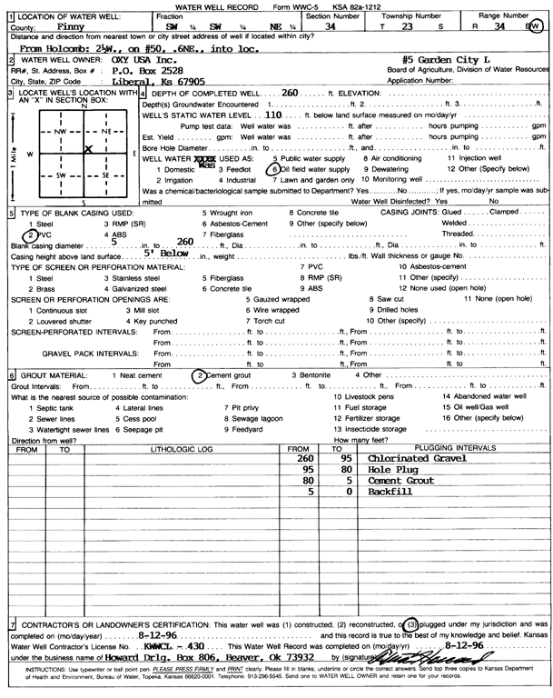
Specific Water Well Detail |
|
|
| Location Info | |||
| Owner: Oxy USA, Inc. | Status: Plugged | ||
| Location: T23S, R34W, Sec. 34, SW SW NE | County: Finney | ||
| Directions: from Holcomb: 2.5 mi W on HWY 50, 0.6 NE into location | |||
| Latitude: 38.0115231 | Longitude: -101.0373232 | Datum NAD 27 | |
| Latitude: 38.0115468 | Longitude: -101.0377678 | Datum NAD 83 | |
| Longitude and latitude calculated by Survey from township-range-section-quarter calls. Only good to within the quarter call accuracy. | |||
| View well on interactive map | |||
| General Info | ||
| Well Depth: 260 ft. | Elevation: ft. | |
| Static Water Level: 110 ft. | Est. Yield: gpm. | |
| Comp. Date: 12-Aug-1996 | Well Use: Oil Field Water Supply | |
| DWR Applic. #: | Other ID: Garden City L 5 | |
| Driller Info | ||
| Driller: Howard Drilling Co. | License #: 430 | |
| Scanned Form | View scan |
| Casing Info | ||
|
Casing Type: PVC
Diam: 5 in. Casing height above land surface: in | ||
| Grout Info | ||
| Grout used: Cement grout | From: 0 to 0 ft
From: 0 to 0 ft From: 0 to 0 ft | |
| Source of Possible Contamination | ||
| Source: | ||
| Direction from well: | Distance: 0 ft | |