|
|
|
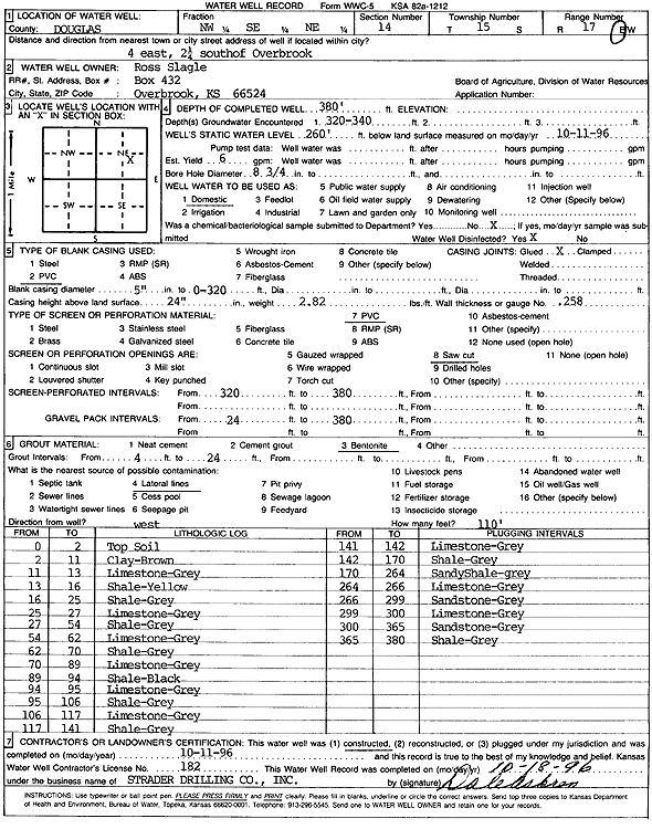
Specific Water Well Detail |
|
|
| Location Info | |||
| Owner: Ross Slagle | Status: Constructed | ||
| Location: T15S, R17E, Sec. 14, NW SE NE | County: Douglas | ||
| Directions: from Overbrook: 4 mi E, 2.25 mi S | |||
| Latitude: 38.7487917 | Longitude: -95.4854396 | Datum NAD 27 | |
| Latitude: 38.7487976 | Longitude: -95.4856966 | Datum NAD 83 | |
| Longitude and latitude calculated by Survey from township-range-section-quarter calls. Only good to within the quarter call accuracy. | |||
| View well on interactive map | |||
| General Info | ||
| Well Depth: 380 ft. | Elevation: ft. | |
| Static Water Level: 260 ft. | Est. Yield: 6 gpm. | |
| Comp. Date: 11-Oct-1996 | Well Use: Domestic | |
| DWR Applic. #: | Other ID: | |
| Driller Info | ||
| Driller: Strader Drilling Co., Inc. | License #: 182 | |
| Scanned Form | View scan |
|
Chemical Sample Submitted?: No
Water Well disinfected?: | ||
| Ground water encountered: 320 ft. , 340 ft. , 0 ft. | ||
| Pump test data: Well water was 0 ft after 0 hours pumping 0 gpm | ||
| Casing Info | ||
| Casing Type: PVC
Casing Joints: |
Diam: 5 in. to 320 ft
Diam: 0 in. to 0 ft Diam: 0 in. to 0 ft | |
| Casing height above land surface: in
Casing Weight: lbs/ft Wall thickness or gauge no.: | ||
| Screen and Perforation Info | ||
| Screen Type: PVC | Screen Openings: Saw cut | |
| Screen-perforated intervals | From: 320 ft to 380 ft
From: 0 ft to 0 ft From: 0 ft to 0 ft | |
| Gravel pack intervals | From: ft to ft | |
| Grout Info | ||
| Grout used: Bentonite | From: 4 to 24 ft
From: 0 to 0 ft From: 0 to 0 ft | |
| Source of Possible Contamination | ||
| Source: Lateral lines | ||
| Direction from well: W | Distance: 110 ft | |
| Lithologic Log
(Log data entered by KGS.) | ||
| From: 0 ft. to 2 ft. | Top soil | |
| From: 2 ft. to 11 ft. | Clay, brown | |
| From: 11 ft. to 13 ft. | Limestone, gray | |
| From: 13 ft. to 16 ft. | Shale, yellow | |
| From: 16 ft. to 25 ft. | Shale, gray | |
| From: 25 ft. to 27 ft. | Limestone, gray | |
| From: 27 ft. to 54 ft. | Shale, gray | |
| From: 54 ft. to 62 ft. | Limestone, gray | |
| From: 62 ft. to 70 ft. | Shale, gray | |
| From: 70 ft. to 89 ft. | Limestone, gray | |
| From: 89 ft. to 94 ft. | Shale, black | |
| From: 94 ft. to 95 ft. | Limestone, gray | |
| From: 95 ft. to 106 ft. | Shale, gray | |
| From: 106 ft. to 117 ft. | Limestone, gray | |
| From: 117 ft. to 141 ft. | Shale, gray | |
| From: 141 ft. to 142 ft. | Limestone, gray | |
| From: 142 ft. to 170 ft. | Shale, gray | |
| From: 170 ft. to 264 ft. | Sandy shale, gray | |
| From: 264 ft. to 266 ft. | Limestone, gray | |
| From: 266 ft. to 299 ft. | Sandstone, gray | |
| From: 299 ft. to 300 ft. | Limestone, gray | |
| From: 300 ft. to 365 ft. | Sandstone, gray | |
| From: 365 ft. to 380 ft. | Shale, gray | |