|
|
|
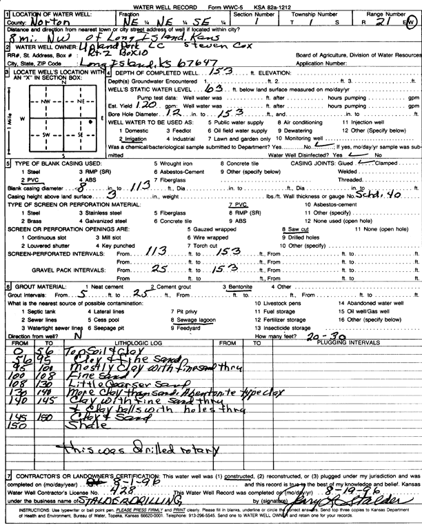
Specific Water Well Detail |
|
|
| Location Info | |||
| Owner: Upland Park/Steven Cox | Status: Constructed | ||
| Location: T1S, R21W, Sec. 1, NE NE SE | County: Norton | ||
| Directions: from Long Island, 8 mi NW | |||
| Latitude: 39.9937105 | Longitude: -99.6262903 | Datum NAD 27 | |
| Latitude: 39.993719 | Longitude: -99.6266778 | Datum NAD 83 | |
| Longitude and latitude calculated by Survey from township-range-section-quarter calls. Only good to within the quarter call accuracy. | |||
| View well on interactive map | |||
| General Info | ||
| Well Depth: 153 ft. | Elevation: ft. | |
| Static Water Level: 63 ft. | Est. Yield: 120 gpm. | |
| Comp. Date: 19-Aug-1996 | Well Use: Irrigation | |
| DWR Applic. #: | Other ID: | |
| Links | |
| No Wizard information available. | |
| View info from WIMAS Water Right Data base... | |
| Driller Info | ||
| Driller: Leo J. Stalder Drilling | License #: 428 | |
| Scanned Form | View scan |
|
Chemical Sample Submitted?:
Water Well disinfected?: | ||
| Ground water encountered: 6300 ft. , 0 ft. , 0 ft. | ||
| Pump test data: Well water was 0 ft after 0 hours pumping 120 gpm | ||
| Casing Info | ||
| Casing Type: PVC
Casing Joints: |
Diam: 800 in. to 1130 ft
Diam: 0 in. to 0 ft Diam: 0 in. to 0 ft | |
| Casing height above land surface: in
Casing Weight: lbs/ft Wall thickness or gauge no.: | ||
| Screen and Perforation Info | ||
| Screen Type: PVC | Screen Openings: Saw cut | |
| Screen-perforated intervals | From: 1130 ft to 1530 ft
From: 25 ft to 153 ft From: 0 ft to 0 ft | |
| Gravel pack intervals | From: ft to ft | |
| Grout Info | ||
| Grout used: Bentonite | From: 5000 to 2500 ft
From: 0 to 0 ft From: 0 to 0 ft | |
| Source of Possible Contamination | ||
| Source: Sewage lagoon | ||
| Direction from well: N | Distance: 30 ft | |
| Lithologic Log
(Log data entered by KGS.) | ||
| From: 0 ft. to 56 ft. | topsoil and clay | |
| From: 56 ft. to 95 ft. | clay and fine sand | |
| From: 95 ft. to 100 ft. | mostly clay with fine sand | |
| From: 100 ft. to 108 ft. | fine sand | |
| From: 108 ft. to 130 ft. | little coarser sand | |
| From: 130 ft. to 140 ft. | more clay than sand, a bentonite type clay | |
| From: 140 ft. to 145 ft. | clay with fine sand thru and clay balls with holes thru | |
| From: 145 ft. to 150 ft. | clay and sand | |
| From: 150 ft. to ft. | shale | |