|
|
|
Specific Water Well Detail |
|
|
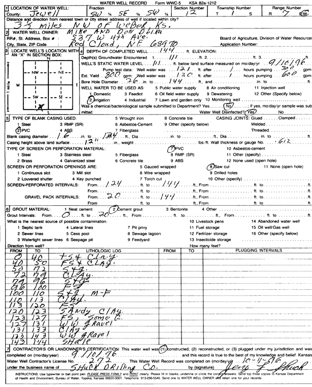
| Location Info | |||
| Owner: Delka, Mike and Don | Status: Constructed | ||
| Location: T1S, R7W, Sec. 12, SW SE SW | County: Jewell | ||
| Directions: from Webber, 3.5 mi NW | |||
| Latitude: 39.9731266 | Longitude: -98.0551066 | Datum NAD 27 | |
| Latitude: 39.9731403 | Longitude: -98.055429 | Datum NAD 83 | |
| Longitude and latitude calculated by Survey from township-range-section-quarter calls. Only good to within the quarter call accuracy. | |||
| View well on interactive map | |||
| General Info | ||
| Well Depth: 144 ft. | Elevation: ft. | |
| Static Water Level: 111 ft. | Est. Yield: 800 gpm. | |
| Comp. Date: 10-Sep-1996 | Well Use: Irrigation | |
| DWR Applic. #: | Other ID: | |
| Links | |
| No Wizard information available. | |
| View info from WIMAS Water Right Data base... | |
| Driller Info | ||
| Driller: Dale Shuck Drilling Co. | License #: 272 | |
| Scanned Form | View scan |
|
Chemical Sample Submitted?: No
Water Well disinfected?: | ||
| Ground water encountered: 111 ft. , 0 ft. , 0 ft. | ||
| Pump test data: Well water was 121 ft after 1 hours pumping 300 gpm | ||
| Casing Info | ||
| Casing Type: PVC
Casing Joints: |
Diam: 16 in. to 124 ft
Diam: 0 in. to 0 ft Diam: 0 in. to 0 ft | |
| Casing height above land surface: in
Casing Weight: lbs/ft Wall thickness or gauge no.: | ||
| Screen and Perforation Info | ||
| Screen Type: PVC | Screen Openings: Saw cut | |
| Screen-perforated intervals | From: 124 ft to 144 ft
From: 0 ft to 0 ft From: 0 ft to 0 ft | |
| Gravel pack intervals | From: ft to ft | |
| Grout Info | ||
| Grout used: Cement grout | From: 0 to 20 ft
From: 0 to 0 ft From: 0 to 0 ft | |
| Source of Possible Contamination | ||
| Source: | ||
| Direction from well: | Distance: 0 ft | |
| Lithologic Log
(Log data entered by KGS.) | ||
| From: 0 ft. to 40 ft. | top soil and clay | |
| From: 40 ft. to 50 ft. | fine sand and clay | |
| From: 50 ft. to 72 ft. | sand and gravel | |
| From: 72 ft. to 79 ft. | clay | |
| From: 79 ft. to 96 ft. | sand and gravel | |
| From: 96 ft. to 100 ft. | sand and gravel, medium-fine | |
| From: 100 ft. to 113 ft. | clay | |
| From: 113 ft. to 120 ft. | fine sand | |
| From: 120 ft. to 123 ft. | sandy clay | |
| From: 123 ft. to 127 ft. | fine sand, some gravel | |
| From: 127 ft. to 131 ft. | white wheat gravel | |
| From: 131 ft. to 133 ft. | clay | |
| From: 133 ft. to 143 ft. | white wheat gravel | |
| From: 143 ft. to 144 ft. | shale | |