|
|
|
Specific Water Well Detail |
|
|
| Location Info | |||
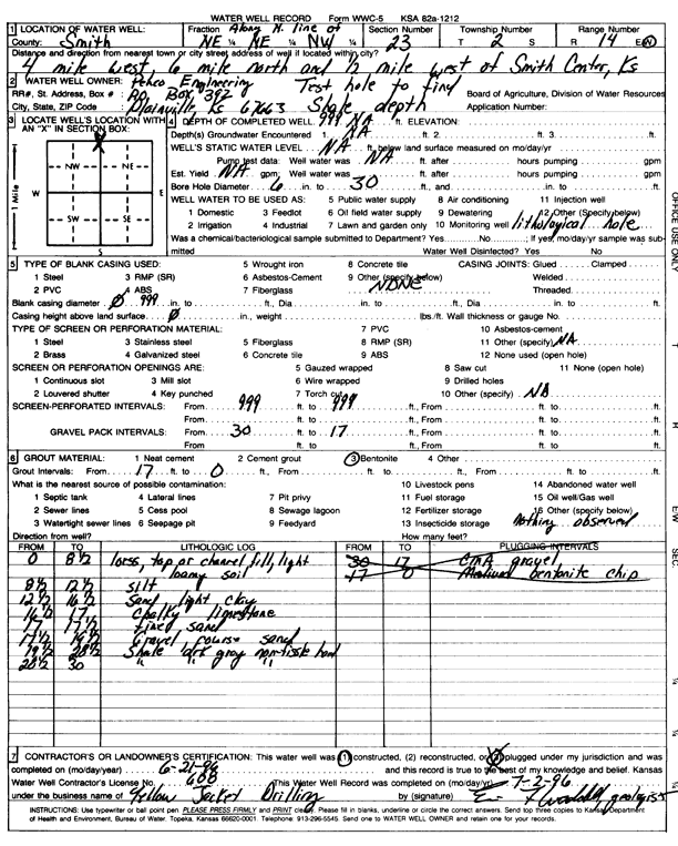
| Owner: Penco Engineering | Status: Constructed | ||
| Location: T2S, R14W, Sec. 23, NE NE NW | County: Smith | ||
| Directions: from Smith Center, 4 mi W, 6 mi N, and 0.5 mi W | |||
| Latitude: 39.87101 | Longitude: -98.8710774 | Datum NAD 27 | |
| Latitude: 39.8710226 | Longitude: -98.8714329 | Datum NAD 83 | |
| Longitude and latitude calculated by Survey from township-range-section-quarter calls. Only good to within the quarter call accuracy. | |||
| View well on interactive map | |||
| General Info | ||
| Well Depth: 30 ft. | Elevation: ft. | |
| Static Water Level: ft. | Est. Yield: gpm. | |
| Comp. Date: 21-Jun-1996 | Well Use: Test hole/well | |
| DWR Applic. #: | Other ID: | |
| Driller Info | ||
| Driller: Yellow Jacket Drilling | License #: 608 | |
| Scanned Form | View scan |
|
Chemical Sample Submitted?: No
Water Well disinfected?: | ||
| Ground water encountered: 0 ft. , 0 ft. , 0 ft. | ||
| Pump test data: Well water was 0 ft after 0 hours pumping 0 gpm | ||
| Casing Info | ||
| Casing Type: OTHER
Casing Joints: |
Diam: 0 in. to 0 ft
Diam: 0 in. to 0 ft Diam: 0 in. to 0 ft | |
| Casing height above land surface: in
Casing Weight: lbs/ft Wall thickness or gauge no.: | ||
| Screen and Perforation Info | ||
| Screen Type: OTHER | Screen Openings: OTHER | |
| Screen-perforated intervals | From: 999 ft to 999 ft
From: 0 ft to 0 ft From: 0 ft to 0 ft | |
| Gravel pack intervals | From: ft to ft | |
| Grout Info | ||
| Grout used: Bentonite | From: 17 to 0 ft
From: 0 to 0 ft From: 0 to 0 ft | |
| Source of Possible Contamination | ||
| Source: Fertilizer storage | ||
| Direction from well: | Distance: 0 ft | |
| Lithologic Log
(Log data entered by KGS.) | ||
| From: 0 ft. to 8.5 ft. | loess, top or channel fill, light loamy soil | |
| From: 8.5 ft. to 12.5 ft. | silt | |
| From: 12.5 ft. to 16.5 ft. | sand, light clay | |
| From: 16.5 ft. to 17 ft. | chalky limestone | |
| From: 17 ft. to 17.5 ft. | fine sand | |
| From: 17.5 ft. to 19.5 ft. | gravel coarse sand | |
| From: 19.5 ft. to 28.5 ft. | shale, dark gray, non-fissile, hard | |
| From: 28.5 ft. to 30 ft. | shale, dark gray, non-fissile | |