|
|
|
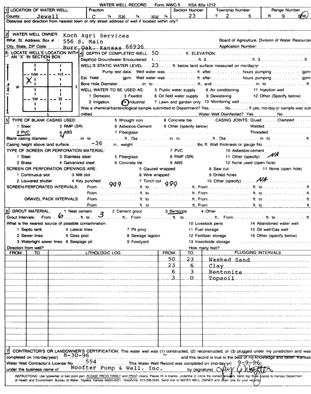
Specific Water Well Detail |
|
|
| Location Info | |||
| Owner: Koch Agri Services | Status: Plugged | ||
| Location: T2S, R9W, Sec. 23, C SW NW | County: Jewell | ||
| Directions: | |||
| Latitude: 39.8660859 | Longitude: -98.3034226 | Datum NAD 27 | |
| Latitude: 39.8660989 | Longitude: -98.3037532 | Datum NAD 83 | |
| Longitude and latitude calculated by Survey from township-range-section-quarter calls. Only good to within the quarter call accuracy. | |||
| View well on interactive map | |||
| General Info | ||
| Well Depth: 50 ft. | Elevation: ft. | |
| Static Water Level: 23 ft. | Est. Yield: gpm. | |
| Comp. Date: 30-Aug-1996 | Well Use: Industrial | |
| DWR Applic. #: | Other ID: | |
| Driller Info | ||
| Driller: Jay C. Woofter Pump & Well, Inc. | License #: 554 | |
| Scanned Form | View scan |
| Casing Info | ||
|
Casing Type: PVC
Diam: 4 in. Casing height above land surface: in | ||
| Grout Info | ||
| Grout used: Bentonite | From: 6 to 3 ft
From: 0 to 0 ft From: 0 to 0 ft | |
| Source of Possible Contamination | ||
| Source: | ||
| Direction from well: | Distance: 0 ft | |