|
|
|
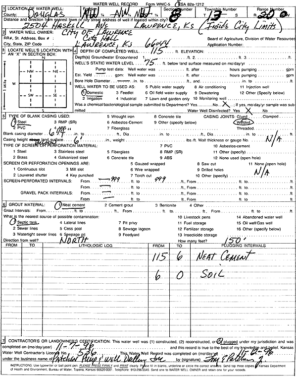
Specific Water Well Detail |
|
|
| Location Info | |||
| Owner: City of Lawrence | Status: Plugged | ||
| Location: T13S, R20E, Sec. 8, NW NW NW | County: Douglas | ||
| Directions: 2504 Haskell Ave, Lawrence | |||
| Latitude: 38.9418789 | Longitude: -95.2220612 | Datum NAD 27 | |
| Latitude: 38.9418818 | Longitude: -95.2223112 | Datum NAD 83 | |
| Longitude and latitude calculated by Survey from township-range-section-quarter calls. Only good to within the quarter call accuracy. | |||
| View well on interactive map | |||
| General Info | ||
| Well Depth: 115 ft. | Elevation: ft. | |
| Static Water Level: 75 ft. | Est. Yield: gpm. | |
| Comp. Date: 07-Nov-1996 | Well Use: Domestic | |
| DWR Applic. #: | Other ID: | |
| Driller Info | ||
| Driller: Tom Patchen Pump & Well Drlg. | License #: 536 | |
| Scanned Form | View scan |
| Casing Info | ||
|
Casing Type: Steel
Diam: 6.1 in. Casing height above land surface: in | ||
| Grout Info | ||
| Grout used: Neat cement | From: 0 to 0 ft
From: 0 to 0 ft From: 0 to 0 ft | |
| Source of Possible Contamination | ||
| Source: Septic Tank | ||
| Direction from well: N | Distance: 150 ft | |