|
|
|
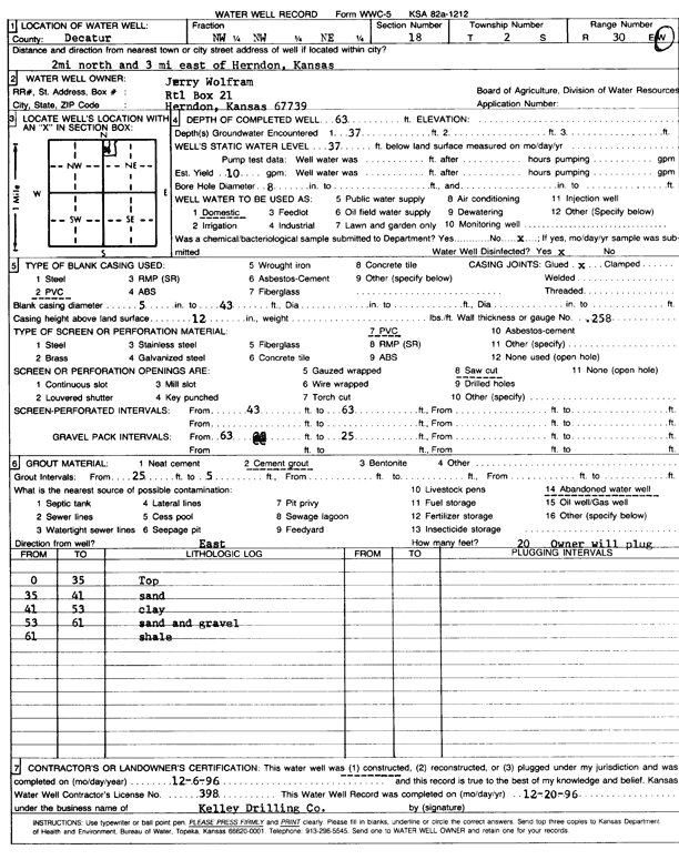
Specific Water Well Detail |
|
|
| Location Info | |||
| Owner: Wolfram, Jerry | Status: Constructed | ||
| Location: T2S, R30W, Sec. 18, NW NW NE | County: Decatur | ||
| Directions: from Herndon, 2 mi N and 3 mi E | |||
| Latitude: 39.8854055 | Longitude: -100.7294872 | Datum NAD 27 | |
| Latitude: 39.8854095 | Longitude: -100.729916 | Datum NAD 83 | |
| Longitude and latitude calculated by Survey from township-range-section-quarter calls. Only good to within the quarter call accuracy. | |||
| View well on interactive map | |||
| General Info | ||
| Well Depth: 63 ft. | Elevation: ft. | |
| Static Water Level: 37 ft. | Est. Yield: 10 gpm. | |
| Comp. Date: 06-Dec-1996 | Well Use: Domestic | |
| DWR Applic. #: | Other ID: | |
| Driller Info | ||
| Driller: Richard O. Kelley Drilling Co. | License #: 398 | |
| Scanned Form | View scan |
|
Chemical Sample Submitted?: No
Water Well disinfected?: | ||
| Ground water encountered: 37 ft. , 0 ft. , 0 ft. | ||
| Pump test data: Well water was 0 ft after 0 hours pumping 0 gpm | ||
| Casing Info | ||
| Casing Type: PVC
Casing Joints: |
Diam: 5 in. to 43 ft
Diam: 0 in. to 0 ft Diam: 0 in. to 0 ft | |
| Casing height above land surface: in
Casing Weight: lbs/ft Wall thickness or gauge no.: | ||
| Screen and Perforation Info | ||
| Screen Type: PVC | Screen Openings: Saw cut | |
| Screen-perforated intervals | From: 43 ft to 63 ft
From: 0 ft to 0 ft From: 0 ft to 0 ft | |
| Gravel pack intervals | From: ft to ft | |
| Grout Info | ||
| Grout used: Cement grout | From: 25 to 5 ft
From: 0 to 0 ft From: 0 to 0 ft | |
| Source of Possible Contamination | ||
| Source: Abandoned water well | ||
| Direction from well: E | Distance: 20 ft | |
| Lithologic Log
(Log data entered by KGS.) | ||
| From: 0 ft. to 35 ft. | top | |
| From: 35 ft. to 41 ft. | sand | |
| From: 41 ft. to 53 ft. | clay | |
| From: 53 ft. to 61 ft. | sand and gravel | |
| From: 61 ft. to ft. | shale | |