|
|
|
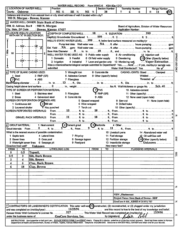
Specific Water Well Detail |
|
|
| Location Info | |||
| Owner: State Bank of Downs | Status: Constructed | ||
| Location: T6S, R11W, Sec. 28, NE SE NE | County: Osborne | ||
| Directions: 900 North Morgan, Downs | |||
| Latitude: 39.5047584 | Longitude: -98.5452157 | Datum NAD 27 | |
| Latitude: 39.5047689 | Longitude: -98.545559 | Datum NAD 83 | |
| Longitude and latitude calculated by Survey from township-range-section-quarter calls. Only good to within the quarter call accuracy. | |||
| View well on interactive map | |||
| General Info | ||
| Well Depth: 18 ft. | Elevation: ft. | |
| Static Water Level: ft. | Est. Yield: gpm. | |
| Comp. Date: 25-Nov-1996 | Well Use: Environmental Remediation, Soil Vapor Extraction | |
| DWR Applic. #: | Other ID: VEW | |
| Driller Info | ||
| Driller: GeoCore Services Inc. | License #: 527 | |
| Scanned Form | View scan |
|
Chemical Sample Submitted?: No
Water Well disinfected?: | ||
| Ground water encountered: 999 ft. , 0 ft. , 0 ft. | ||
| Pump test data: Well water was 0 ft after 0 hours pumping 0 gpm | ||
| Casing Info | ||
| Casing Type: PVC
Casing Joints: |
Diam: 2 in. to 13 ft
Diam: 0 in. to 0 ft Diam: 0 in. to 0 ft | |
| Casing height above land surface: in
Casing Weight: lbs/ft Wall thickness or gauge no.: | ||
| Screen and Perforation Info | ||
| Screen Type: PVC | Screen Openings: Mill slot | |
| Screen-perforated intervals | From: 13 ft to 18 ft
From: 0 ft to 0 ft From: 0 ft to 0 ft | |
| Gravel pack intervals | From: ft to ft | |
| Grout Info | ||
| Grout used: Cement grout, Bentonite | From: 0 to 9 ft
From: 9 to 11 ft From: 0 to 0 ft | |
| Source of Possible Contamination | ||
| Source: OTHER | ||
| Direction from well: | Distance: 0 ft | |
| Lithologic Log
(Log data entered by KGS.) | ||
| From: 0 ft. to .5 ft. | top soil | |
| From: .5 ft. to 2 ft. | silt, dark brown | |
| From: 2 ft. to 4 ft. | silt, brown | |
| From: 4 ft. to 6 ft. | clay, dark brown | |
| From: 6 ft. to 18 ft. | clay, brown | |