|
|
|
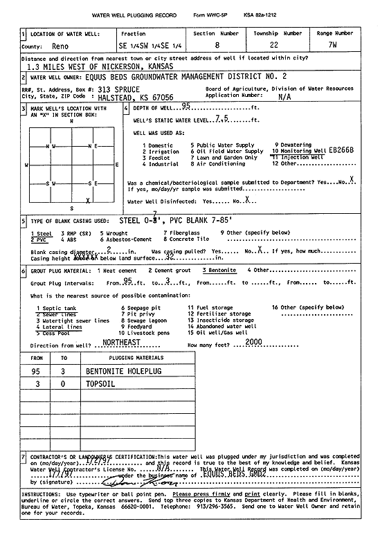
Specific Water Well Detail |
|
|
| Location Info | |||
| Owner: Equus Beds GMD 2 | Status: Plugged | ||
| Location: T22S, R7W, Sec. 8, SE SW SE | County: Reno | ||
| Directions: from Nickerson: 1.3 mi W | |||
| Latitude: 38.1456739 | Longitude: -98.1112134 | Datum NAD 27 | |
| Latitude: 38.1456852 | Longitude: -98.1115492 | Datum NAD 83 | |
| Longitude and latitude calculated by Survey from township-range-section-quarter calls. Only good to within the quarter call accuracy. | |||
| View well on interactive map | |||
| General Info | ||
| Well Depth: 95 ft. | Elevation: ft. | |
| Static Water Level: 7.5 ft. | Est. Yield: gpm. | |
| Comp. Date: 02-Jan-1996 | Well Use: Monitoring well/observation/piezometer | |
| DWR Applic. #: | Other ID: EB 266B | |
| Driller Info | ||
| Driller: Equus Beds GMD 2 | License #: | |
| Scanned Form | View scan |
| Casing Info | ||
|
Casing Type: PVC
Diam: 2 in. Casing height above land surface: in | ||
| Grout Info | ||
| Grout used: Bentonite | From: 95 to 3 ft
From: 0 to 0 ft From: 0 to 0 ft | |
| Source of Possible Contamination | ||
| Source: Septic Tank | ||
| Direction from well: NE | Distance: 200 ft | |