|
|
|
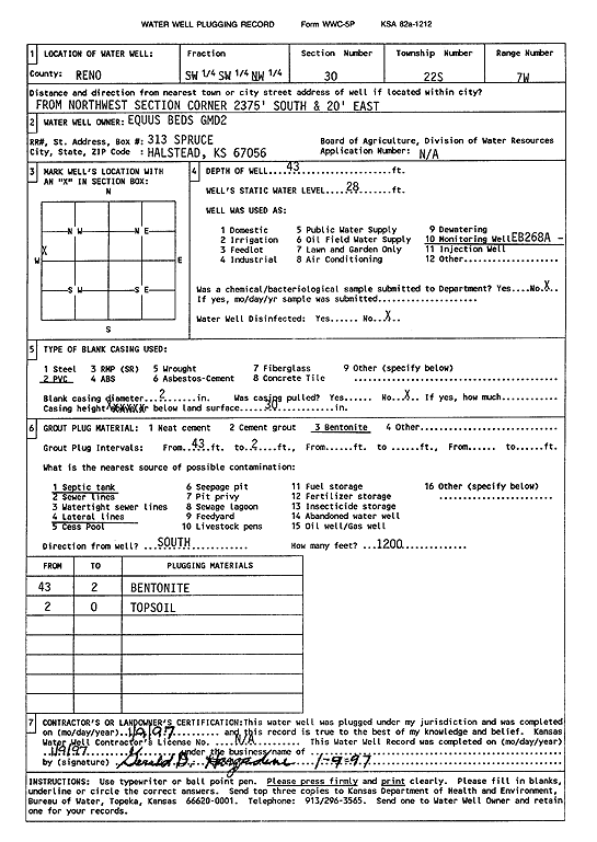
Specific Water Well Detail |
|
|
| Location Info | |||
| Owner: Equus Beds GMD 2 | Status: Plugged | ||
| Location: T22S, R7W, Sec. 30, SW SW NW | County: Reno | ||
| Directions: from NW section corner: 2375' S, 20' E | |||
| Latitude: 38.1093404 | Longitude: -98.1408174 | Datum NAD 27 | |
| Latitude: 38.1093522 | Longitude: -98.1411547 | Datum NAD 83 | |
| Longitude and latitude calculated by Survey from township-range-section-quarter calls. Only good to within the quarter call accuracy. | |||
| View well on interactive map | |||
| General Info | ||
| Well Depth: 43 ft. | Elevation: ft. | |
| Static Water Level: 28 ft. | Est. Yield: gpm. | |
| Comp. Date: 09-Jan-1997 | Well Use: Monitoring well/observation/piezometer | |
| DWR Applic. #: | Other ID: EB 268A | |
| Driller Info | ||
| Driller: Gerold D. Hargadine | License #: | |
| Scanned Form | View scan |
| Casing Info | ||
|
Casing Type: PVC
Diam: 2 in. Casing height above land surface: in | ||
| Grout Info | ||
| Grout used: Bentonite | From: 43 to 2 ft
From: 0 to 0 ft From: 0 to 0 ft | |
| Source of Possible Contamination | ||
| Source: Septic Tank | ||
| Direction from well: S | Distance: 120 ft | |