|
|
|
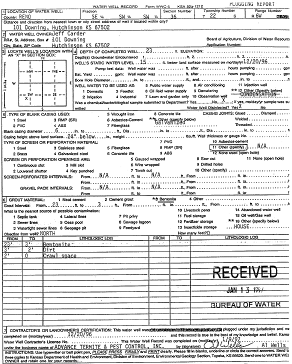
Specific Water Well Detail |
|
|
| Location Info | |||
| Owner: Carder, Jeff | Status: Plugged | ||
| Location: T22S, R6W, Sec. 36, SE SW SW | County: Reno | ||
| Directions: 101 Downing, Hutchinson | |||
| Latitude: 38.0872722 | Longitude: -97.9367169 | Datum NAD 27 | |
| Latitude: 38.0872833 | Longitude: -97.9370468 | Datum NAD 83 | |
| Longitude and latitude calculated by Survey from township-range-section-quarter calls. Only good to within the quarter call accuracy. | |||
| View well on interactive map | |||
| General Info | ||
| Well Depth: 23 ft. | Elevation: ft. | |
| Static Water Level: 15 ft. | Est. Yield: gpm. | |
| Comp. Date: 20-Dec-1996 | Well Use: Injection well/air sparge (AS)/shallow | |
| DWR Applic. #: | Other ID: | |
| Driller Info | ||
| Driller: Advance Termite and Pest Control, Inc. | License #: | |
| Scanned Form | View scan |
| Casing Info | ||
|
Casing Type: OTHER
Diam: 6 in. Casing height above land surface: in | ||
| Grout Info | ||
| Grout used: Bentonite | From: 23 to 3 ft
From: 0 to 0 ft From: 0 to 0 ft | |
| Source of Possible Contamination | ||
| Source: OTHER | ||
| Direction from well: N | Distance: 0 ft | |