|
|
|
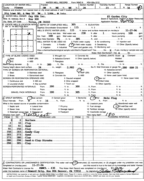
Specific Water Well Detail |
|
|
| Location Info | |||
| Owner: Oxy USA, Inc. | Status: Constructed | ||
| Location: T23S, R34W, Sec. 28, SW NE NE | County: Finney | ||
| Directions: from Big Lowe Rd and Hwy 50, 3 mi W, and 1.75 mi N, W into site | |||
| Latitude: 38.0296098 | Longitude: -101.0509049 | Datum NAD 27 | |
| Latitude: 38.0296332 | Longitude: -101.0513491 | Datum NAD 83 | |
| Longitude and latitude calculated by Survey from township-range-section-quarter calls. Only good to within the quarter call accuracy. | |||
| View well on interactive map | |||
| General Info | ||
| Well Depth: 305 ft. | Elevation: ft. | |
| Static Water Level: 115 ft. | Est. Yield: 100 gpm. | |
| Comp. Date: 27-Nov-1996 | Well Use: Oil Field Water Supply | |
| DWR Applic. #: 960456 | Other ID: Garden City 3 | |
| Links | |
| No Wizard information available. | |
| View info from WIMAS Water Right Data base... | |
| Driller Info | ||
| Driller: Howard Drilling Co. | License #: 430 | |
| Scanned Form | View scan |
|
Chemical Sample Submitted?: No
Water Well disinfected?: | ||
| Ground water encountered: 1150 ft. , 0 ft. , 0 ft. | ||
| Pump test data: Well water was 0 ft after 0 hours pumping 0 gpm | ||
| Casing Info | ||
| Casing Type: PVC
Casing Joints: |
Diam: 5 in. to 30 ft
Diam: 0 in. to 0 ft Diam: 0 in. to 0 ft | |
| Casing height above land surface: in
Casing Weight: lbs/ft Wall thickness or gauge no.: | ||
| Screen and Perforation Info | ||
| Screen Type: PVC | Screen Openings: Saw cut | |
| Screen-perforated intervals | From: 20 ft to 30 ft
From: 0 ft to 0 ft From: 0 ft to 0 ft | |
| Gravel pack intervals | From: ft to ft | |
| Grout Info | ||
| Grout used: Neat cement, | From: 0 to 16 ft
From: 0 to 0 ft From: 0 to 0 ft | |
| Source of Possible Contamination | ||
| Source: Oil well/gas well | ||
| Direction from well: NE | Distance: 180 ft | |
| Lithologic Log
(Log data entered by KGS.) | ||
| From: 0 ft. to 2 ft. | surface | |
| From: 2 ft. to 33 ft. | clay | |
| From: 33 ft. to 91 ft. | sand | |
| From: 91 ft. to 150 ft. | clay | |
| From: 150 ft. to 183 ft. | sandy clay | |
| From: 183 ft. to 273 ft. | sand | |
| From: 273 ft. to 280 ft. | clay | |
| From: 280 ft. to 298 ft. | sand and clay streaks | |
| From: 298 ft. to 305 ft. | clay | |