|
|
|
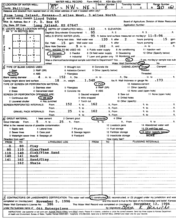
Specific Water Well Detail |
|
|
| Location Info | |||
| Owner: Tubbs, Lloyd | Status: Constructed | ||
| Location: T1S, R20W, Sec. 8, C NW NE | County: Phillips | ||
| Directions: from Long Island, 2 mi W and 3 mi N | |||
| Latitude: 39.9856843 | Longitude: -99.5951396 | Datum NAD 27 | |
| Latitude: 39.9856931 | Longitude: -99.5955256 | Datum NAD 83 | |
| Longitude and latitude calculated by Survey from township-range-section-quarter calls. Only good to within the quarter call accuracy. | |||
| View well on interactive map | |||
| General Info | ||
| Well Depth: 162 ft. | Elevation: ft. | |
| Static Water Level: 95 ft. | Est. Yield: 15 gpm. | |
| Comp. Date: 05-Nov-1996 | Well Use: Domestic | |
| DWR Applic. #: | Other ID: | |
| Driller Info | ||
| Driller: Paul Ott Enterprises | License #: 386 | |
| Scanned Form | View scan |
|
Chemical Sample Submitted?: No
Water Well disinfected?: | ||
| Ground water encountered: 95 ft. , 0 ft. , 0 ft. | ||
| Pump test data: Well water was 0 ft after 0 hours pumping 0 gpm | ||
| Casing Info | ||
| Casing Type: PVC
Casing Joints: |
Diam: 4 in. to 152 ft
Diam: 0 in. to 0 ft Diam: 0 in. to 0 ft | |
| Casing height above land surface: in
Casing Weight: lbs/ft Wall thickness or gauge no.: | ||
| Screen and Perforation Info | ||
| Screen Type: PVC | Screen Openings: Mill slot | |
| Screen-perforated intervals | From: 152 ft to 162 ft
From: 0 ft to 0 ft From: 0 ft to 0 ft | |
| Gravel pack intervals | From: ft to ft | |
| Grout Info | ||
| Grout used: Bentonite | From: 5 to 25 ft
From: 0 to 0 ft From: 0 to 0 ft | |
| Source of Possible Contamination | ||
| Source: | ||
| Direction from well: | Distance: 0 ft | |
| Lithologic Log
(Log data entered by KGS.) | ||
| From: 0 ft. to 80 ft. | clay | |
| From: 80 ft. to 110 ft. | clay, sand | |
| From: 110 ft. to 140 ft. | clay, fine sand | |
| From: 140 ft. to 141 ft. | rock | |
| From: 141 ft. to 162 ft. | sand, clay | |
| From: ft. to 162 ft. | shale | |