|
|
|
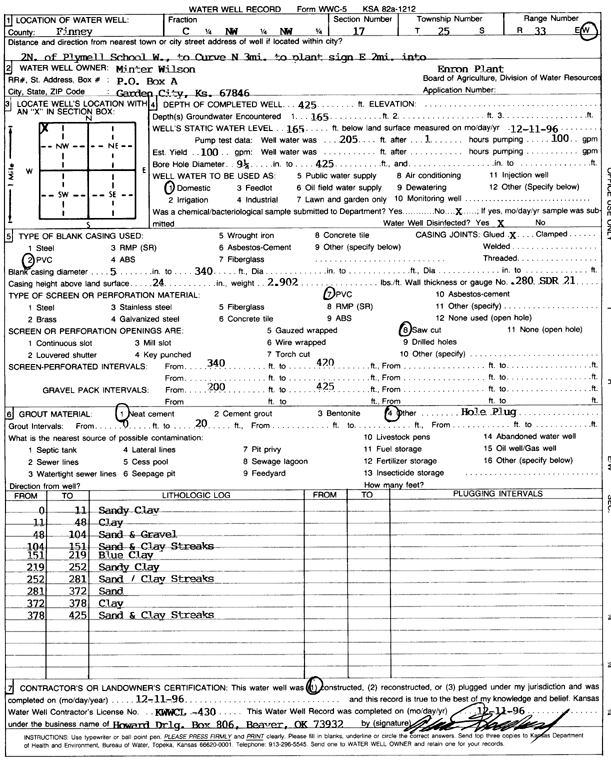
Specific Water Well Detail |
|
|
| Location Info | |||
| Owner: Minter-Wilson Drilling Co. | Status: Constructed | ||
| Location: T25S, R33W, Sec. 17, C NW NW | County: Finney | ||
| Directions: 2 N of Plymell School, W to curve, 3 mi N to plant sign, 2 mi E into site | |||
| Latitude: 37.8858201 | Longitude: -100.9721475 | Datum NAD 27 | |
| Latitude: 37.885844 | Longitude: -100.9725919 | Datum NAD 83 | |
| Longitude and latitude calculated by Survey from township-range-section-quarter calls. Only good to within the quarter call accuracy. | |||
| View well on interactive map | |||
| General Info | ||
| Well Depth: 425 ft. | Elevation: ft. | |
| Static Water Level: 165 ft. | Est. Yield: 100 gpm. | |
| Comp. Date: 11-Dec-1996 | Well Use: Domestic | |
| DWR Applic. #: | Other ID: | |
| Driller Info | ||
| Driller: Howard Drilling Co. | License #: 430 | |
| Scanned Form | View scan |
|
Chemical Sample Submitted?: No
Water Well disinfected?: | ||
| Ground water encountered: 165 ft. , 0 ft. , 0 ft. | ||
| Pump test data: Well water was 0 ft after 0 hours pumping 0 gpm | ||
| Casing Info | ||
| Casing Type: PVC
Casing Joints: |
Diam: 5 in. to 340 ft
Diam: 0 in. to 0 ft Diam: 0 in. to 0 ft | |
| Casing height above land surface: in
Casing Weight: lbs/ft Wall thickness or gauge no.: | ||
| Screen and Perforation Info | ||
| Screen Type: PVC | Screen Openings: Saw cut | |
| Screen-perforated intervals | From: 340 ft to 420 ft
From: 0 ft to 0 ft From: 0 ft to 0 ft | |
| Gravel pack intervals | From: ft to ft | |
| Grout Info | ||
| Grout used: Neat cement, | From: 0 to 20 ft
From: 0 to 0 ft From: 0 to 0 ft | |
| Source of Possible Contamination | ||
| Source: | ||
| Direction from well: | Distance: 0 ft | |
| Lithologic Log
(Log data entered by KGS.) | ||
| From: 0 ft. to 11 ft. | sandy clay | |
| From: 11 ft. to 48 ft. | clay | |
| From: 48 ft. to 104 ft. | sand and gravel | |
| From: 104 ft. to 151 ft. | sand and clay streaks | |
| From: 151 ft. to 219 ft. | blue clay | |
| From: 219 ft. to 252 ft. | sandy clay | |
| From: 252 ft. to 281 ft. | sand / clay streaks | |
| From: 281 ft. to 372 ft. | sand | |
| From: 372 ft. to 378 ft. | clay | |
| From: 378 ft. to 425 ft. | sand and clay streaks | |