|
|
|
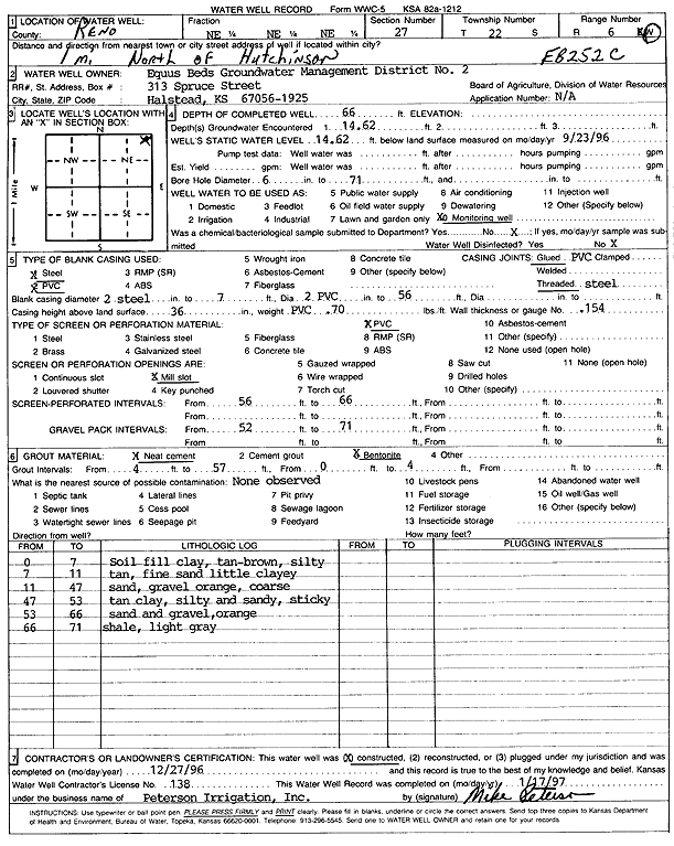
Specific Water Well Detail |
|
|
| Location Info | |||
| Owner: Equus Beds GMD 2 | Status: Constructed | ||
| Location: T22S, R6W, Sec. 27, NE NE NE | County: Reno | ||
| Directions: from Hutchinson: 1 mi N | |||
| Latitude: 38.1137415 | Longitude: -97.9601089 | Datum NAD 27 | |
| Latitude: 38.1137524 | Longitude: -97.9604392 | Datum NAD 83 | |
| Longitude and latitude calculated by Survey from township-range-section-quarter calls. Only good to within the quarter call accuracy. | |||
| View well on interactive map | |||
| General Info | ||
| Well Depth: 66 ft. | Elevation: ft. | |
| Static Water Level: 14.62 ft. | Est. Yield: gpm. | |
| Comp. Date: 27-Dec-1996 | Well Use: Monitoring well/observation/piezometer | |
| DWR Applic. #: | Other ID: EB 252C | |
| Links | |
| View info from Wizard Water Level Data base... | |
| No WIMAS information available. | |
| Driller Info | ||
| Driller: Michael Peterson Irrigation, Inc. | License #: 138 | |
| Scanned Form | View scan |
|
Chemical Sample Submitted?: No
Water Well disinfected?: | ||
| Ground water encountered: 14.62 ft. , 0 ft. , 0 ft. | ||
| Pump test data: Well water was 0 ft after 0 hours pumping 0 gpm | ||
| Casing Info | ||
| Casing Type: Steel
Casing Joints: |
Diam: 2 in. to 7 ft
Diam: 0 in. to 0 ft Diam: 0 in. to 0 ft | |
| Casing height above land surface: in
Casing Weight: lbs/ft Wall thickness or gauge no.: | ||
| Screen and Perforation Info | ||
| Screen Type: PVC | Screen Openings: Mill slot | |
| Screen-perforated intervals | From: 56 ft to 66 ft
From: 0 ft to 0 ft From: 0 ft to 0 ft | |
| Gravel pack intervals | From: ft to ft | |
| Grout Info | ||
| Grout used: Neat cement, Bentonite | From: 4 to 57 ft
From: 0 to 4 ft From: 0 to 0 ft | |
| Source of Possible Contamination | ||
| Source: | ||
| Direction from well: | Distance: 0 ft | |
| Lithologic Log
(Log data entered by KGS.) | ||
| From: 0 ft. to 7 ft. | soil, fill, silty clay, tan brown | |
| From: 7 ft. to 11 ft. | fine sand, tan, little clayey | |
| From: 11 ft. to 47 ft. | sand and gravel, orange, coarse | |
| From: 47 ft. to 53 ft. | tan silty and sandy clay, sticky | |
| From: 53 ft. to 66 ft. | sand and gravel, orange | |
| From: 66 ft. to 71 ft. | shale, light gray | |