|
|
|
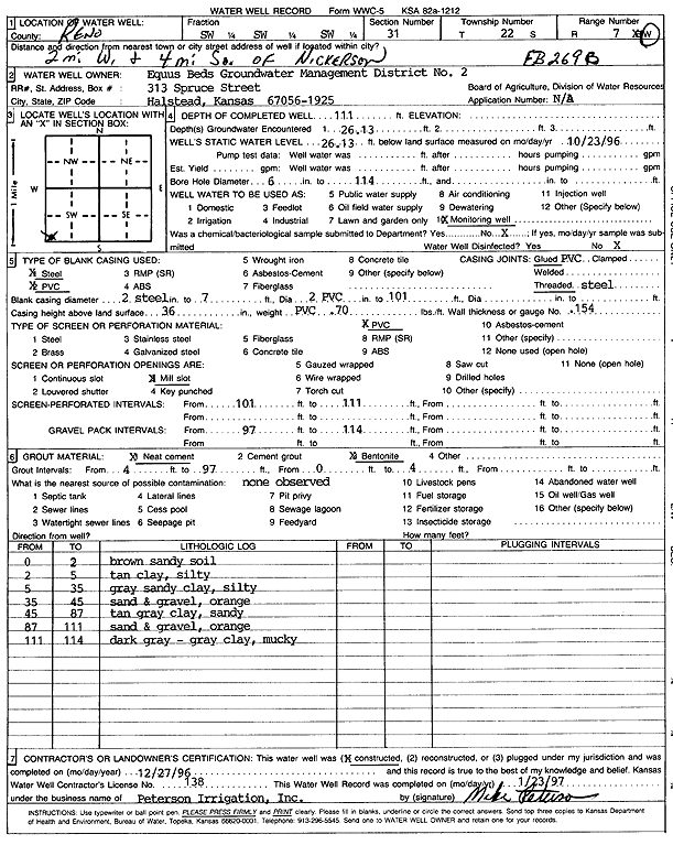
Specific Water Well Detail |
|
|
| Location Info | |||
| Owner: Equus Beds GMD 2 | Status: Constructed | ||
| Location: T22S, R7W, Sec. 31, SW SW SW | County: Reno | ||
| Directions: from Nickerson: 2 mi W, 4 mi S | |||
| Latitude: 38.0875576 | Longitude: -98.1407999 | Datum NAD 27 | |
| Latitude: 38.0875695 | Longitude: -98.1411374 | Datum NAD 83 | |
| Longitude and latitude calculated by Survey from township-range-section-quarter calls. Only good to within the quarter call accuracy. | |||
| View well on interactive map | |||
| General Info | ||
| Well Depth: 111 ft. | Elevation: ft. | |
| Static Water Level: 26.13 ft. | Est. Yield: gpm. | |
| Comp. Date: 27-Dec-1996 | Well Use: Monitoring well/observation/piezometer | |
| DWR Applic. #: | Other ID: EB 269B | |
| Links | |
| View info from Wizard Water Level Data base... | |
| No WIMAS information available. | |
| Driller Info | ||
| Driller: Peterson Irrigation, Inc. | License #: 138 | |
| Scanned Form | View scan |
|
Chemical Sample Submitted?: No
Water Well disinfected?: | ||
| Ground water encountered: 26.13 ft. , 0 ft. , 0 ft. | ||
| Pump test data: Well water was 0 ft after 0 hours pumping 0 gpm | ||
| Casing Info | ||
| Casing Type: Steel
Casing Joints: |
Diam: 2 in. to 7 ft
Diam: 0 in. to 0 ft Diam: 0 in. to 0 ft | |
| Casing height above land surface: in
Casing Weight: lbs/ft Wall thickness or gauge no.: | ||
| Screen and Perforation Info | ||
| Screen Type: PVC | Screen Openings: Mill slot | |
| Screen-perforated intervals | From: 101 ft to 111 ft
From: 0 ft to 0 ft From: 0 ft to 0 ft | |
| Gravel pack intervals | From: ft to ft | |
| Grout Info | ||
| Grout used: Neat cement, Bentonite | From: 4 to 97 ft
From: 0 to 4 ft From: 0 to 0 ft | |
| Source of Possible Contamination | ||
| Source: | ||
| Direction from well: | Distance: 0 ft | |
| Lithologic Log
(Log data entered by KGS.) | ||
| From: 0 ft. to 2 ft. | brown sandy clay | |
| From: 2 ft. to 5 ft. | silty tan clay | |
| From: 5 ft. to 35 ft. | gray sandy clay, silty | |
| From: 35 ft. to 45 ft. | sand and gravel, orange | |
| From: 45 ft. to 87 ft. | tan gray sandy clay | |
| From: 87 ft. to 111 ft. | sand and gravel, orange | |
| From: 111 ft. to 114 ft. | dark gray-gray clay, mucky | |