|
|
|
Specific Water Well Detail |
|
|
| Location Info | |||
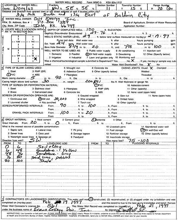
| Owner: Colt Energy, Inc. | Status: Constructed | ||
| Location: T15S, R20E, Sec. 11, NW SE SE | County: Douglas | ||
| Directions: from Baldwin City: .75 mi S, 1.75 mi E | |||
| Latitude: 38.7558019 | Longitude: -95.1520478 | Datum NAD 27 | |
| Latitude: 38.7558096 | Longitude: -95.1522962 | Datum NAD 83 | |
| Longitude and latitude calculated by Survey from township-range-section-quarter calls. Only good to within the quarter call accuracy. | |||
| View well on interactive map | |||
| General Info | ||
| Well Depth: 100 ft. | Elevation: ft. | |
| Static Water Level: 29 ft. | Est. Yield: 24 gpm. | |
| Comp. Date: 19-Feb-1997 | Well Use: Oil Field Water Supply | |
| DWR Applic. #: | Other ID: | |
| Links | |
| No Wizard information available. | |
| View info from WIMAS Water Right Data base... | |
| Driller Info | ||
| Driller: Evans Energy Development, Inc. | License #: 561 | |
| Scanned Form | View scan |
|
Chemical Sample Submitted?: No
Water Well disinfected?: | ||
| Ground water encountered: 76 ft. , 0 ft. , 0 ft. | ||
| Pump test data: Well water was 0 ft after 0 hours pumping 0 gpm | ||
| Casing Info | ||
| Casing Type: PVC
Casing Joints: |
Diam: 5 in. to 90 ft
Diam: 0 in. to 0 ft Diam: 0 in. to 0 ft | |
| Casing height above land surface: in
Casing Weight: lbs/ft Wall thickness or gauge no.: | ||
| Screen and Perforation Info | ||
| Screen Type: PVC | Screen Openings: Mill slot | |
| Screen-perforated intervals | From: 90 ft to 100 ft
From: 0 ft to 0 ft From: 0 ft to 0 ft | |
| Gravel pack intervals | From: ft to ft | |
| Grout Info | ||
| Grout used: Bentonite | From: 20 to 0 ft
From: 0 to 0 ft From: 0 to 0 ft | |
| Source of Possible Contamination | ||
| Source: Oil well/gas well | ||
| Direction from well: SW | Distance: 100 ft | |
| Lithologic Log
(Log data entered by KGS.) | ||
| From: 0 ft. to 6 ft. | soil and clay | |
| From: 6 ft. to 48 ft. | sandstone, yellow | |
| From: 48 ft. to 76 ft. | sandstone, gray | |
| From: 76 ft. to 80 ft. | sand, limestone, pebbles | |
| From: 80 ft. to 100 ft. | shale | |