|
|
|
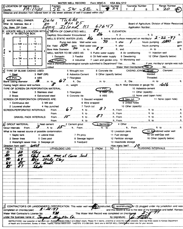
Specific Water Well Detail |
|
|
| Location Info | |||
| Owner: Tubbs, Dale | Status: Reconstructed | ||
| Location: T1S, R20W, Sec. 24, SE SW SE | County: Phillips | ||
| Directions: | |||
| Latitude: 39.9450413 | Longitude: -99.5206962 | Datum NAD 27 | |
| Latitude: 39.9450506 | Longitude: -99.5210788 | Datum NAD 83 | |
| Longitude and latitude calculated by Survey from township-range-section-quarter calls. Only good to within the quarter call accuracy. | |||
| View well on interactive map | |||
| General Info | ||
| Well Depth: 87 ft. | Elevation: ft. | |
| Static Water Level: 26 ft. | Est. Yield: 1150 gpm. | |
| Comp. Date: 22-Feb-1997 | Well Use: Irrigation | |
| DWR Applic. #: | Other ID: | |
| Links | |
| No Wizard information available. | |
| View info from WIMAS Water Right Data base... | |
| Driller Info | ||
| Driller: Chas. Sargent Irrigation Co., Inc. | License #: 433 | |
| Scanned Form | View scan |
|
Chemical Sample Submitted?: No
Water Well disinfected?: | ||
| Ground water encountered: 26 ft. , 0 ft. , 0 ft. | ||
| Pump test data: Well water was 0 ft after 0 hours pumping 0 gpm | ||
| Casing Info | ||
| Casing Type: PVC
Casing Joints: |
Diam: 16 in. to 67 ft
Diam: 0 in. to 0 ft Diam: 0 in. to 0 ft | |
| Casing height above land surface: in
Casing Weight: lbs/ft Wall thickness or gauge no.: | ||
| Screen and Perforation Info | ||
| Screen Type: PVC | Screen Openings: Saw cut | |
| Screen-perforated intervals | From: 67 ft to 87 ft
From: 0 ft to 0 ft From: 0 ft to 0 ft | |
| Gravel pack intervals | From: ft to ft | |
| Grout Info | ||
| Grout used: Bentonite | From: 3 to 15 ft
From: 0 to 0 ft From: 0 to 0 ft | |
| Source of Possible Contamination | ||
| Source: Abandoned water well | ||
| Direction from well: W | Distance: 10 ft | |
| Lithologic Log
(Log data entered by KGS.) | ||
| From: 0 ft. to 20 ft. | clay | |
| From: 20 ft. to 40 ft. | clay with trace of coarse sand | |
| From: 40 ft. to 64 ft. | blue sticky clay | |
| From: 64 ft. to 85 ft. | fine gravel | |
| From: 85 ft. to 87 ft. | shale | |