|
|
|
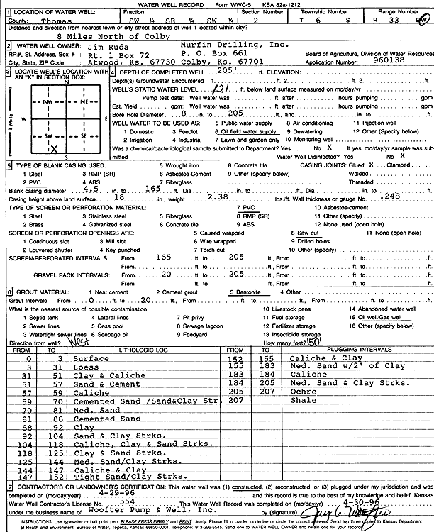
Specific Water Well Detail |
|
|
| Location Info | |||
| Owner: Murfin Drilling Co. | Status: Constructed | ||
| Location: T6S, R33W, Sec. 2, SW SE SW | County: Thomas | ||
| Directions: from Colby: 8 mi N | |||
| Latitude: 39.5547186 | Longitude: -100.9734319 | Datum NAD 27 | |
| Latitude: 39.5547214 | Longitude: -100.9738639 | Datum NAD 83 | |
| Longitude and latitude calculated by Survey from township-range-section-quarter calls. Only good to within the quarter call accuracy. | |||
| View well on interactive map | |||
| General Info | ||
| Well Depth: 205 ft. | Elevation: ft. | |
| Static Water Level: 121 ft. | Est. Yield: gpm. | |
| Comp. Date: 29-Apr-1996 | Well Use: Oil Field Water Supply | |
| DWR Applic. #: 960138 | Other ID: | |
| Links | |
| No Wizard information available. | |
| View info from WIMAS Water Right Data base... | |
| Driller Info | ||
| Driller: Jay C. Woofter Pump & Well, Inc. | License #: 554 | |
| Scanned Form | View scan |
|
Chemical Sample Submitted?: No
Water Well disinfected?: | ||
| Ground water encountered: 0 ft. , 0 ft. , 0 ft. | ||
| Pump test data: Well water was 0 ft after 0 hours pumping 0 gpm | ||
| Casing Info | ||
| Casing Type: PVC
Casing Joints: |
Diam: 4.5 in. to 165 ft
Diam: 0 in. to 0 ft Diam: 0 in. to 0 ft | |
| Casing height above land surface: in
Casing Weight: lbs/ft Wall thickness or gauge no.: | ||
| Screen and Perforation Info | ||
| Screen Type: PVC | Screen Openings: Saw cut | |
| Screen-perforated intervals | From: 165 ft to 205 ft
From: 0 ft to 0 ft From: 0 ft to 0 ft | |
| Gravel pack intervals | From: ft to ft | |
| Grout Info | ||
| Grout used: Bentonite | From: 0 to 20 ft
From: 0 to 0 ft From: 0 to 0 ft | |
| Source of Possible Contamination | ||
| Source: Oil well/gas well | ||
| Direction from well: W | Distance: 150 ft | |
| Lithologic Log
(Log data entered by KGS.) | ||
| From: 0 ft. to 3 ft. | Surface | |
| From: 3 ft. to 31 ft. | Loess | |
| From: 31 ft. to 51 ft. | Clay and caliche | |
| From: 51 ft. to 57 ft. | Sand and cement | |
| From: 57 ft. to 59 ft. | Caliche | |
| From: 59 ft. to 70 ft. | Cemented sand, sand and clay streaks | |
| From: 70 ft. to 81 ft. | Medium sand | |
| From: 81 ft. to 88 ft. | Cemented sand | |
| From: 88 ft. to 92 ft. | Clay | |
| From: 92 ft. to 104 ft. | Sand and clay streaks | |
| From: 104 ft. to 118 ft. | Caliche, clay and sand streaks | |
| From: 118 ft. to 125 ft. | Clay and sand streaks | |
| From: 125 ft. to 144 ft. | Medium sand, clay streaks | |
| From: 144 ft. to 147 ft. | Caliche and clay | |
| From: 147 ft. to 152 ft. | Tight sand, clay streaks | |
| From: 152 ft. to 155 ft. | Caliche and clay | |
| From: 155 ft. to 183 ft. | Medium sand with 2 inches of clay | |
| From: 183 ft. to 184 ft. | Caliche | |
| From: 184 ft. to 205 ft. | Medium sand and clay streaks | |
| From: 205 ft. to 207 ft. | Ochre | |
| From: 207 ft. to ft. | Shale | |