|
|
|
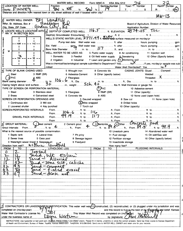
Specific Water Well Detail |
|
|
| Location Info | |||
| Owner: BFI Landfill | Status: Constructed | ||
| Location: T24S, R32W, Sec. 19, SW NE SW | County: Finney | ||
| Directions: | |||
| Latitude: 37.9504944 | Longitude: -100.8773262 | Datum NAD 27 | |
| Latitude: 37.9505176 | Longitude: -100.8777662 | Datum NAD 83 | |
| Longitude and latitude calculated by Survey from township-range-section-quarter calls. Only good to within the quarter call accuracy. | |||
| View well on interactive map | |||
| General Info | ||
| Well Depth: 116.5 ft. | Elevation: 2874.05 ft. | |
| Static Water Level: 103 ft. | Est. Yield: gpm. | |
| Comp. Date: 03-Feb-1997 | Well Use: Monitoring well/observation/piezometer | |
| DWR Applic. #: | Other ID: MW 13 | |
| Driller Info | ||
| Driller: Layne Western | License #: 581 | |
| Scanned Form | View scan |
|
Chemical Sample Submitted?: No
Water Well disinfected?: | ||
| Ground water encountered: 0 ft. , 0 ft. , 0 ft. | ||
| Pump test data: Well water was 0 ft after 0 hours pumping 0 gpm | ||
| Casing Info | ||
| Casing Type: PVC
Casing Joints: |
Diam: 4 in. to 106.6 ft
Diam: 0 in. to 0 ft Diam: 0 in. to 0 ft | |
| Casing height above land surface: in
Casing Weight: lbs/ft Wall thickness or gauge no.: | ||
| Screen and Perforation Info | ||
| Screen Type: PVC | Screen Openings: Wire wrapped | |
| Screen-perforated intervals | From: 106.6 ft to 116 ft
From: 0 ft to 0 ft From: 0 ft to 0 ft | |
| Gravel pack intervals | From: ft to ft | |
| Grout Info | ||
| Grout used: Neat cement, Bentonite | From: 0 to 4 ft
From: 4 to 89.5 ft From: 89.5 to 99.9 ft | |
| Source of Possible Contamination | ||
| Source: | ||
| Direction from well: | Distance: 0 ft | |
| Lithologic Log
(Log data entered by KGS.) | ||
| From: 0 ft. to 2 ft. | topsoil | |
| From: 2 ft. to 12 ft. | sand, silt eolian | |
| From: 12 ft. to 18 ft. | sand - alluvial | |
| From: 18 ft. to 32 ft. | sand - some silt, caliche | |
| From: 32 ft. to 43 ft. | sand - compact | |
| From: 43 ft. to 83 ft. | sand - fine-med gravel | |
| From: 83 ft. to 117 ft. | sand - dense wet | |