|
|
|
Specific Water Well Detail |
|
|
| Location Info | |||
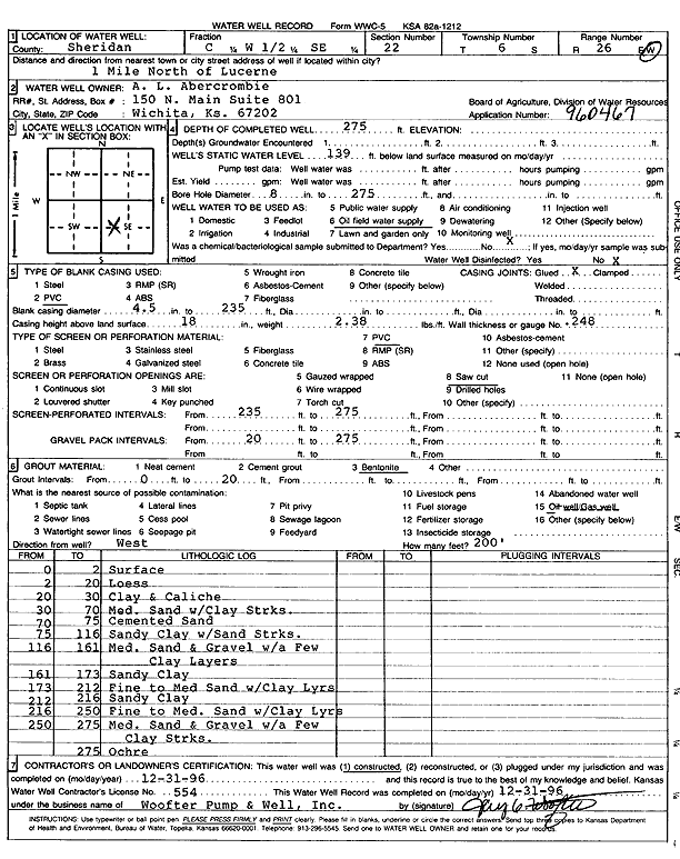
| Owner: A.L. Abercrombie | Status: Constructed | ||
| Location: T6S, R26W, Sec. 22, C W2 SE | County: Sheridan | ||
| Directions: from Lucerne: 1 mi N | |||
| Latitude: 39.5126971 | Longitude: -100.2061092 | Datum NAD 27 | |
| Latitude: 39.5127005 | Longitude: -100.2065225 | Datum NAD 83 | |
| Longitude and latitude calculated by Survey from township-range-section-quarter calls. Only good to within the quarter call accuracy. | |||
| View well on interactive map | |||
| General Info | ||
| Well Depth: 275 ft. | Elevation: ft. | |
| Static Water Level: 139 ft. | Est. Yield: gpm. | |
| Comp. Date: 31-Dec-1996 | Well Use: Oil Field Water Supply | |
| DWR Applic. #: 960467 | Other ID: | |
| Links | |
| No Wizard information available. | |
| View info from WIMAS Water Right Data base... | |
| Driller Info | ||
| Driller: Woofter Pump & Well, Inc. | License #: 554 | |
| Scanned Form | View scan |
|
Chemical Sample Submitted?: No
Water Well disinfected?: | ||
| Ground water encountered: 0 ft. , 0 ft. , 0 ft. | ||
| Pump test data: Well water was 0 ft after 0 hours pumping 0 gpm | ||
| Casing Info | ||
| Casing Type: PVC
Casing Joints: |
Diam: 4.5 in. to 235 ft
Diam: 0 in. to 0 ft Diam: 0 in. to 0 ft | |
| Casing height above land surface: in
Casing Weight: lbs/ft Wall thickness or gauge no.: | ||
| Screen and Perforation Info | ||
| Screen Type: PVC | Screen Openings: Saw cut | |
| Screen-perforated intervals | From: 235 ft to 275 ft
From: 0 ft to 0 ft From: 0 ft to 0 ft | |
| Gravel pack intervals | From: ft to ft | |
| Grout Info | ||
| Grout used: Bentonite | From: 0 to 20 ft
From: 0 to 0 ft From: 0 to 0 ft | |
| Source of Possible Contamination | ||
| Source: Oil well/gas well | ||
| Direction from well: W | Distance: 200 ft | |
| Lithologic Log
(Log data entered by KGS.) | ||
| From: 0 ft. to 2 ft. | Surface | |
| From: 2 ft. to 20 ft. | Loess | |
| From: 20 ft. to 30 ft. | Clay and caliche | |
| From: 30 ft. to 70 ft. | Medium sand with clay streaks | |
| From: 70 ft. to 75 ft. | Cemented sand | |
| From: 75 ft. to 116 ft. | Sandy clay with sand streaks | |
| From: 116 ft. to 161 ft. | Medium sand and gravel with a few clay layers | |
| From: 161 ft. to 173 ft. | Sandy clay | |
| From: 173 ft. to 212 ft. | Fine to medium sand with clay layers | |
| From: 212 ft. to 216 ft. | Sandy clay | |
| From: 216 ft. to 250 ft. | Fine to medium sand with clay layers | |
| From: 250 ft. to 275 ft. | Medium sand and gravel with a few clay streaks | |
| From: 275 ft. to ft. | Ochre | |