|
|
|
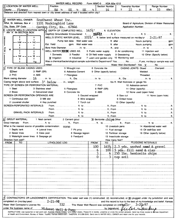
Specific Water Well Detail |
|
|
| Location Info | |||
| Owner: Southwest Wheat, Inc. | Status: Plugged | ||
| Location: T22S, R33W, Sec. 14, SW SE SE | County: Finney | ||
| Directions: | |||
| Latitude: 38.1353876 | Longitude: -100.9048841 | Datum NAD 27 | |
| Latitude: 38.1354103 | Longitude: -100.9053216 | Datum NAD 83 | |
| Longitude and latitude calculated by Survey from township-range-section-quarter calls. Only good to within the quarter call accuracy. | |||
| View well on interactive map | |||
| General Info | ||
| Well Depth: 145.5 ft. | Elevation: ft. | |
| Static Water Level: 102.5 ft. | Est. Yield: gpm. | |
| Comp. Date: 21-Feb-1997 | Well Use: Irrigation | |
| DWR Applic. #: | Other ID: | |
| Links | |
| View info from Wizard Water Level Data base... | |
| View info from WIMAS Water Right Data base... | |
| Driller Info | ||
| Driller: Midwest Well & Pump, Inc. | License #: 532 | |
| Scanned Form | View scan |
| Casing Info | ||
|
Casing Type: Steel
Diam: 16 in. Casing height above land surface: in | ||
| Grout Info | ||
| Grout used: Bentonite | From: 0 to 0 ft
From: 0 to 0 ft From: 0 to 0 ft | |
| Source of Possible Contamination | ||
| Source: | ||
| Direction from well: | Distance: 0 ft | |