|
|
|
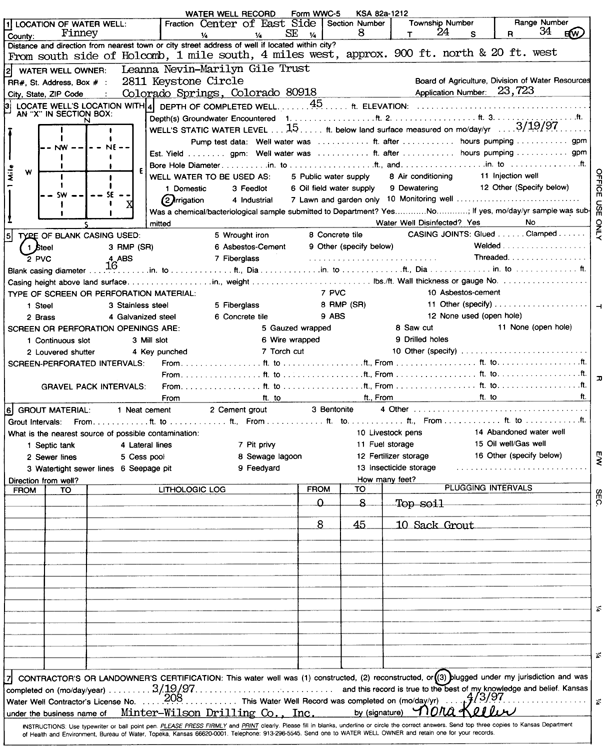
Specific Water Well Detail |
|
|
| Location Info | |||
| Owner: Leanna Nevin-Marilyn Gile Trust | Status: Plugged | ||
| Location: T24S, R34W, Sec. 8, C E2 SE | County: Finney | ||
| Directions: from S side of Holcomb: 1 mi S, 4 mi W, 900 feet N, and 20 feet W | |||
| Latitude: 37.9778757 | Longitude: -101.0681533 | Datum NAD 27 | |
| Latitude: 37.9778987 | Longitude: -101.0685986 | Datum NAD 83 | |
| Longitude and latitude calculated by Survey from township-range-section-quarter calls. Only good to within the quarter call accuracy. | |||
| View well on interactive map | |||
| General Info | ||
| Well Depth: 45 ft. | Elevation: ft. | |
| Static Water Level: 15 ft. | Est. Yield: gpm. | |
| Comp. Date: 19-Mar-1997 | Well Use: Irrigation | |
| DWR Applic. #: 23723 | Other ID: | |
| Links | |
| View info from Wizard Water Level Data base... | |
| View info from WIMAS Water Right Data base... | |
| Driller Info | ||
| Driller: MW Drilling | License #: 208 | |
| Scanned Form | View scan |
| Casing Info | ||
|
Casing Type: Steel
Diam: 16 in. Casing height above land surface: in | ||
| Grout Info | ||
| Grout used: Bentonite | From: 8 to 45 ft
From: 0 to 0 ft From: 0 to 0 ft | |
| Source of Possible Contamination | ||
| Source: | ||
| Direction from well: | Distance: 0 ft | |