|
|
|
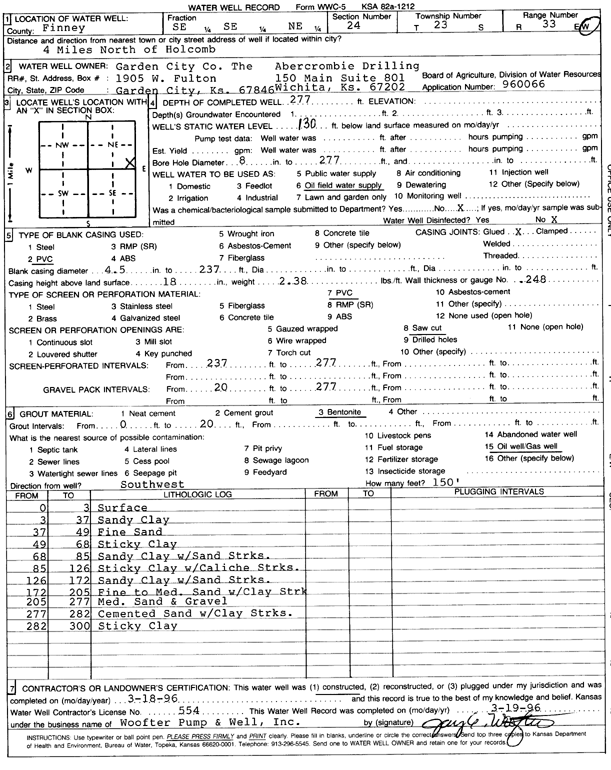
Specific Water Well Detail |
|
|
| Location Info | |||
| Owner: Garden City Co./Abercrombie Drilling | Status: Constructed | ||
| Location: T23S, R33W, Sec. 24, SE SE NE | County: Finney | ||
| Directions: from Holcomb, 4 mi N | |||
| Latitude: 38.0412165 | Longitude: -100.8841161 | Datum NAD 27 | |
| Latitude: 38.0412395 | Longitude: -100.8845549 | Datum NAD 83 | |
| Longitude and latitude calculated by Survey from township-range-section-quarter calls. Only good to within the quarter call accuracy. | |||
| View well on interactive map | |||
| General Info | ||
| Well Depth: 277 ft. | Elevation: ft. | |
| Static Water Level: 130 ft. | Est. Yield: gpm. | |
| Comp. Date: 18-Mar-1996 | Well Use: Oil Field Water Supply | |
| DWR Applic. #: 960666 | Other ID: | |
| Links | |
| No Wizard information available. | |
| View info from WIMAS Water Right Data base... | |
| Driller Info | ||
| Driller: Woofter Pump & Well #554 | License #: 554 | |
| Scanned Form | View scan |
|
Chemical Sample Submitted?: No
Water Well disinfected?: | ||
| Ground water encountered: 0 ft. , 0 ft. , 0 ft. | ||
| Pump test data: Well water was 0 ft after 0 hours pumping 0 gpm | ||
| Casing Info | ||
| Casing Type: PVC
Casing Joints: |
Diam: 4.5 in. to 237 ft
Diam: 0 in. to 0 ft Diam: 0 in. to 0 ft | |
| Casing height above land surface: in
Casing Weight: lbs/ft Wall thickness or gauge no.: | ||
| Screen and Perforation Info | ||
| Screen Type: PVC | Screen Openings: Saw cut | |
| Screen-perforated intervals | From: 237 ft to 277 ft
From: 0 ft to 0 ft From: 0 ft to 0 ft | |
| Gravel pack intervals | From: ft to ft | |
| Grout Info | ||
| Grout used: Bentonite | From: 0 to 20 ft
From: 0 to 0 ft From: 0 to 0 ft | |
| Source of Possible Contamination | ||
| Source: Oil well/gas well | ||
| Direction from well: SW | Distance: 150 ft | |
| Lithologic Log
(Log data entered by KGS.) | ||
| From: 0 ft. to 3 ft. | surface | |
| From: 3 ft. to 37 ft. | sandy clay | |
| From: 37 ft. to 49 ft. | fine sand | |
| From: 49 ft. to 68 ft. | sticky clay | |
| From: 68 ft. to 85 ft. | sandy clay with sand streaks | |
| From: 85 ft. to 126 ft. | sticky clay with caliche streaks | |
| From: 126 ft. to 172 ft. | sandy clay with sand streaks | |
| From: 172 ft. to 205 ft. | fine to medium sand with clay strk | |
| From: 205 ft. to 277 ft. | medium sand and gravel | |
| From: 277 ft. to 282 ft. | cemented sand with clay streaks | |
| From: 282 ft. to 300 ft. | sticky clay | |