|
|
|
Specific Water Well Detail |
|
|
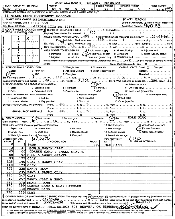
| Location Info | |||
| Owner: Helmerich and Payne Inc. | Status: Constructed | ||
| Location: T25S, R34W, Sec. 31, W2 NW NE | County: Finney | ||
| Directions: from Holcomb, 11 mi SSW | |||
| Latitude: 37.8414284 | Longitude: -101.0930535 | Datum NAD 27 | |
| Latitude: 37.8414505 | Longitude: -101.0935005 | Datum NAD 83 | |
| Longitude and latitude calculated by Survey from township-range-section-quarter calls. Only good to within the quarter call accuracy. | |||
| View well on interactive map | |||
| General Info | ||
| Well Depth: 360 ft. | Elevation: ft. | |
| Static Water Level: 100 ft. | Est. Yield: 75 gpm. | |
| Comp. Date: 03-Apr-1996 | Well Use: Oil Field Water Supply | |
| DWR Applic. #: 960133 | Other ID: Brown 1-31 | |
| Links | |
| No Wizard information available. | |
| View info from WIMAS Water Right Data base... | |
| Driller Info | ||
| Driller: Howard Drilling Company AG, LLC | License #: 430 | |
| Scanned Form | View scan |
|
Chemical Sample Submitted?: No
Water Well disinfected?: | ||
| Ground water encountered: 100 ft. , 0 ft. , 0 ft. | ||
| Pump test data: Well water was 120 ft after 1 hours pumping 75 gpm | ||
| Casing Info | ||
| Casing Type: PVC
Casing Joints: |
Diam: 5 in. to 360 ft
Diam: 0 in. to 0 ft Diam: 0 in. to 0 ft | |
| Casing height above land surface: in
Casing Weight: lbs/ft Wall thickness or gauge no.: | ||
| Screen and Perforation Info | ||
| Screen Type: PVC | Screen Openings: Saw cut | |
| Screen-perforated intervals | From: 280 ft to 360 ft
From: 0 ft to 0 ft From: 0 ft to 0 ft | |
| Gravel pack intervals | From: ft to ft | |
| Grout Info | ||
| Grout used: Neat cement, | From: 0 to 16 ft
From: 0 to 0 ft From: 0 to 0 ft | |
| Source of Possible Contamination | ||
| Source: Oil well/gas well | ||
| Direction from well: W | Distance: 100 ft | |
| Lithologic Log
(Log data entered by KGS.) | ||
| From: 0 ft. to 2 ft. | sand | |
| From: 2 ft. to 45 ft. | sand and sandy clay | |
| From: 45 ft. to 60 ft. | coarse sand and small gravel | |
| From: 60 ft. to 93 ft. | med. and large gravel | |
| From: 93 ft. to 125 ft. | clay | |
| From: 125 ft. to 140 ft. | clay and sandy clay | |
| From: 140 ft. to 173 ft. | clay | |
| From: 173 ft. to 225 ft. | sandy clay | |
| From: 225 ft. to 235 ft. | sand and sandy clay | |
| From: 235 ft. to 247 ft. | clay | |
| From: 247 ft. to 257 ft. | sandy clay and sand | |
| From: 257 ft. to 270 ft. | coarse sand | |
| From: 270 ft. to 290 ft. | coarse sand and clay streaks | |
| From: 290 ft. to 330 ft. | coarse sand | |
| From: 330 ft. to 335 ft. | clay | |
| From: 335 ft. to 360 ft. | sand | |