|
|
|
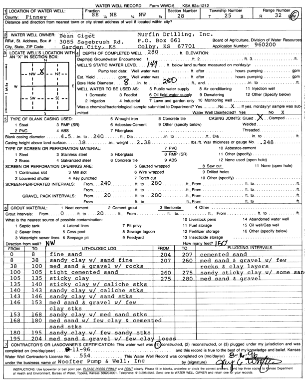
Specific Water Well Detail |
|
|
| Location Info | |||
| Owner: Murfin Drilling/Dean Gigot | Status: Constructed | ||
| Location: T25S, R32W, Sec. 28, SE NE NW | County: Finney | ||
| Directions: | |||
| Latitude: 37.8558875 | Longitude: -100.8388877 | Datum NAD 27 | |
| Latitude: 37.8559109 | Longitude: -100.8393272 | Datum NAD 83 | |
| Longitude and latitude calculated by Survey from township-range-section-quarter calls. Only good to within the quarter call accuracy. | |||
| View well on interactive map | |||
| General Info | ||
| Well Depth: 280 ft. | Elevation: ft. | |
| Static Water Level: 147 ft. | Est. Yield: gpm. | |
| Comp. Date: 11-Aug-1996 | Well Use: Oil Field Water Supply | |
| DWR Applic. #: 960200 | Other ID: | |
| Links | |
| No Wizard information available. | |
| View info from WIMAS Water Right Data base... | |
| Driller Info | ||
| Driller: Jay C. Woofter Pump & Well, Inc. | License #: 554 | |
| Scanned Form | View scan |
|
Chemical Sample Submitted?: No
Water Well disinfected?: | ||
| Ground water encountered: 0 ft. , 0 ft. , 0 ft. | ||
| Pump test data: Well water was 0 ft after 0 hours pumping 0 gpm | ||
| Casing Info | ||
| Casing Type: PVC
Casing Joints: |
Diam: 4.5 in. to 240 ft
Diam: 0 in. to 0 ft Diam: 0 in. to 0 ft | |
| Casing height above land surface: in
Casing Weight: lbs/ft Wall thickness or gauge no.: | ||
| Screen and Perforation Info | ||
| Screen Type: PVC | Screen Openings: Saw cut | |
| Screen-perforated intervals | From: 240 ft to 280 ft
From: 0 ft to 0 ft From: 0 ft to 0 ft | |
| Gravel pack intervals | From: ft to ft | |
| Grout Info | ||
| Grout used: Bentonite | From: 0 to 20 ft
From: 0 to 0 ft From: 0 to 0 ft | |
| Source of Possible Contamination | ||
| Source: | ||
| Direction from well: NW | Distance: 150 ft | |
| Lithologic Log
(Log data entered by KGS.) | ||
| From: 0 ft. to 8 ft. | fine sand | |
| From: 8 ft. to 38 ft. | sandy clay with sand fine | |
| From: 38 ft. to 100 ft. | medium sand and gravel with rocks | |
| From: 100 ft. to 105 ft. | tight cemented sand | |
| From: 105 ft. to 135 ft. | sticky clay | |
| From: 135 ft. to 140 ft. | sticky clay with caliche streaks | |
| From: 140 ft. to 143 ft. | sandy clay with caliche stks | |
| From: 143 ft. to 146 ft. | sandy clay with sand streaks | |
| From: 146 ft. to 153 ft. | medium sand and gravel with few clay streaks | |
| From: 153 ft. to 168 ft. | sandy clay with medium sand streaks | |
| From: 168 ft. to 180 ft. | medium sand with few clay and cemented sand streaks | |
| From: 180 ft. to 195 ft. | sandy clay with few sandy stks | |
| From: 195 ft. to 204 ft. | medium sand and gravel with few clay loess | |
| From: 204 ft. to 207 ft. | cemented sand | |
| From: 207 ft. to 260 ft. | medium sand and gravel with few rocks and clay layers | |
| From: 260 ft. to 275 ft. | sandy sticky clay with some sand | |
| From: 275 ft. to 280 ft. | medium sand and gravel | |