|
|
|
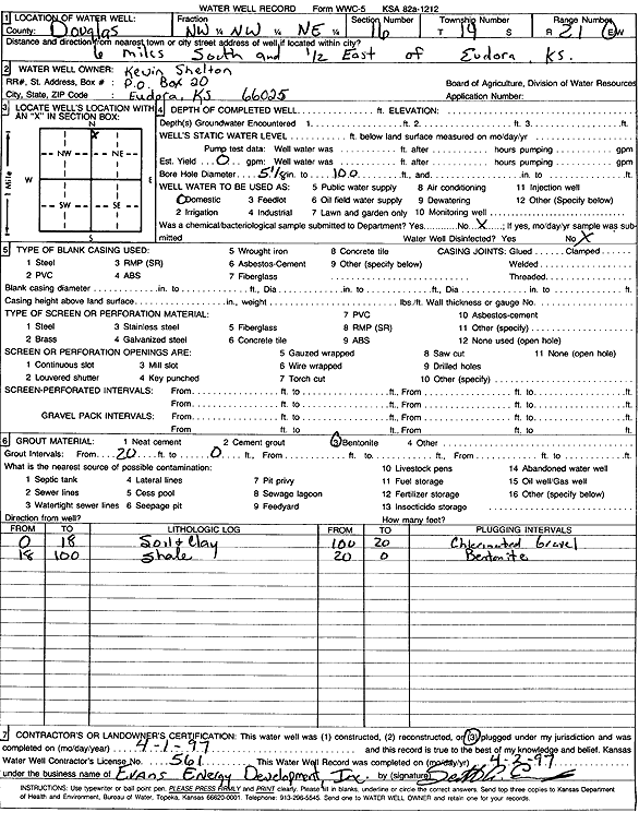
Specific Water Well Detail |
|
|
| Location Info | |||
| Owner: Shelton, Kevin | Status: Plugged | ||
| Location: T14S, R21E, Sec. 16, NW NW NE | County: Douglas | ||
| Directions: from Eudora: 6 mi S, .5 mi E | |||
| Latitude: 38.8397169 | Longitude: -95.0825397 | Datum NAD 27 | |
| Latitude: 38.8397231 | Longitude: -95.0827865 | Datum NAD 83 | |
| Longitude and latitude calculated by Survey from township-range-section-quarter calls. Only good to within the quarter call accuracy. | |||
| View well on interactive map | |||
| General Info | ||
| Well Depth: 100 ft. | Elevation: ft. | |
| Static Water Level: ft. | Est. Yield: gpm. | |
| Comp. Date: 01-Apr-1997 | Well Use: Domestic | |
| DWR Applic. #: | Other ID: | |
| Driller Info | ||
| Driller: Evans Energy Development, Inc. | License #: 561 | |
| Scanned Form | View scan |
| Casing Info | ||
|
Casing Type:
Diam: 0 in. Casing height above land surface: in | ||
| Grout Info | ||
| Grout used: Bentonite | From: 20 to 0 ft
From: 0 to 0 ft From: 0 to 0 ft | |
| Source of Possible Contamination | ||
| Source: | ||
| Direction from well: | Distance: 0 ft | |
| Lithologic Log
(Log data entered by KGS.) | ||
| From: 0 ft. to 18 ft. | soil and clay | |
| From: 18 ft. to 100 ft. | shale | |