|
|
|
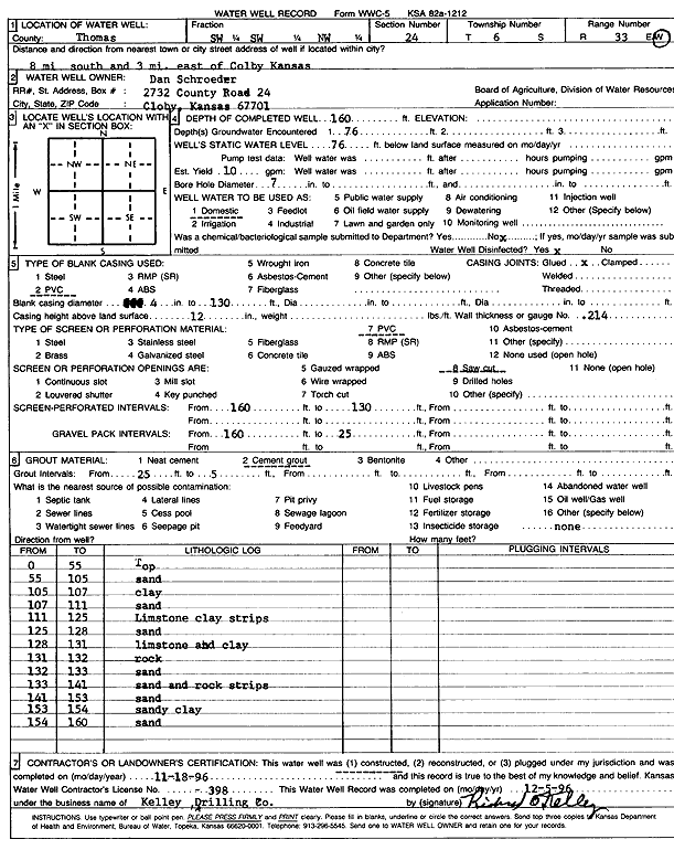
Specific Water Well Detail |
|
|
| Location Info | |||
| Owner: Schroeder, Dan | Status: Constructed | ||
| Location: T6S, R33W, Sec. 24, SW SW NW | County: Thomas | ||
| Directions: from Colby: 8 mi S, 3 mi E | |||
| Latitude: 39.5185955 | Longitude: -100.959502 | Datum NAD 27 | |
| Latitude: 39.5185984 | Longitude: -100.9599336 | Datum NAD 83 | |
| Longitude and latitude calculated by Survey from township-range-section-quarter calls. Only good to within the quarter call accuracy. | |||
| View well on interactive map | |||
| General Info | ||
| Well Depth: 160 ft. | Elevation: ft. | |
| Static Water Level: 76 ft. | Est. Yield: 10 gpm. | |
| Comp. Date: 18-Nov-1996 | Well Use: Domestic | |
| DWR Applic. #: | Other ID: | |
| Driller Info | ||
| Driller: Richard O. Kelley Drilling Co. | License #: 398 | |
| Scanned Form | View scan |
|
Chemical Sample Submitted?: No
Water Well disinfected?: | ||
| Ground water encountered: 76 ft. , 0 ft. , 0 ft. | ||
| Pump test data: Well water was 0 ft after 0 hours pumping 0 gpm | ||
| Casing Info | ||
| Casing Type: PVC
Casing Joints: |
Diam: 4 in. to 130 ft
Diam: 0 in. to 0 ft Diam: 0 in. to 0 ft | |
| Casing height above land surface: in
Casing Weight: lbs/ft Wall thickness or gauge no.: | ||
| Screen and Perforation Info | ||
| Screen Type: PVC | Screen Openings: Saw cut | |
| Screen-perforated intervals | From: 160 ft to 130 ft
From: 0 ft to 0 ft From: 0 ft to 0 ft | |
| Gravel pack intervals | From: ft to ft | |
| Grout Info | ||
| Grout used: Cement grout | From: 25 to 5 ft
From: 0 to 0 ft From: 0 to 0 ft | |
| Source of Possible Contamination | ||
| Source: | ||
| Direction from well: | Distance: 0 ft | |
| Lithologic Log
(Log data entered by KGS.) | ||
| From: 0 ft. to 55 ft. | Top | |
| From: 55 ft. to 105 ft. | Sand | |
| From: 105 ft. to 107 ft. | Clay | |
| From: 107 ft. to 111 ft. | Sand | |
| From: 111 ft. to 125 ft. | Limestone clay strips | |
| From: 125 ft. to 128 ft. | Sand | |
| From: 128 ft. to 131 ft. | Limestone and clay | |
| From: 131 ft. to 132 ft. | Rock | |
| From: 132 ft. to 133 ft. | Sand | |
| From: 133 ft. to 141 ft. | Sand and rock strips | |
| From: 141 ft. to 153 ft. | Sand | |
| From: 153 ft. to 154 ft. | Sandy clay | |
| From: 154 ft. to 160 ft. | Sand | |