|
|
|
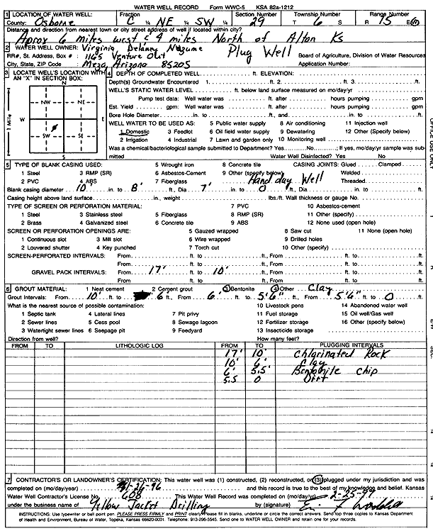
Specific Water Well Detail |
|
|
| Location Info | |||
| Owner: Nuzum, Virginia Delany | Status: Plugged | ||
| Location: T6S, R15W, Sec. 29, C NE SW | County: Osborne | ||
| Directions: from Alton, 6 mi W and 4 mi N | |||
| Latitude: 39.5005803 | Longitude: -99.0196488 | Datum NAD 27 | |
| Latitude: 39.5005907 | Longitude: -99.0200126 | Datum NAD 83 | |
| Longitude and latitude calculated by Survey from township-range-section-quarter calls. Only good to within the quarter call accuracy. | |||
| View well on interactive map | |||
| General Info | ||
| Well Depth: 17 ft. | Elevation: ft. | |
| Static Water Level: ft. | Est. Yield: gpm. | |
| Comp. Date: 26-Jan-1996 | Well Use: Domestic | |
| DWR Applic. #: | Other ID: | |
| Driller Info | ||
| Driller: Yellow Jacket Drilling | License #: 608 | |
| Scanned Form | View scan |
| Casing Info | ||
|
Casing Type: OTHER
Diam: 10 in. Casing height above land surface: in | ||
| Grout Info | ||
| Grout used: Bentonite, | From: 10 to 6 ft
From: 6 to 5.6 ft From: 0 to 0 ft | |
| Source of Possible Contamination | ||
| Source: | ||
| Direction from well: | Distance: 0 ft | |