|
|
|
Specific Water Well Detail |
|
|
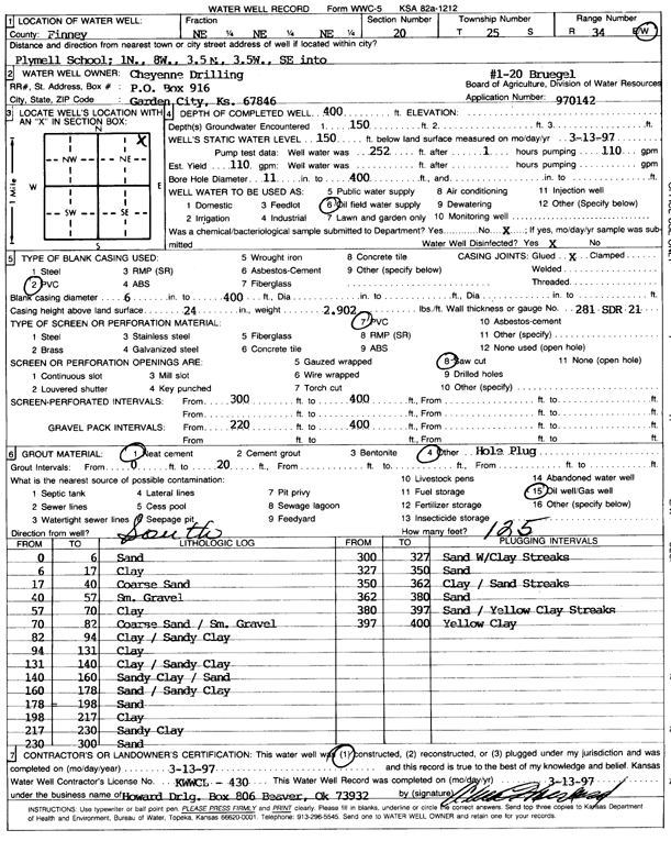
| Location Info | |||
| Owner: Cheyenne Drilling | Status: Constructed | ||
| Location: T25S, R34W, Sec. 20, NE NE NE | County: Finney | ||
| Directions: from Plymell school: 1 mi N, 8 mi W, 3.5 mi N, 3.5 mi W, SE into site | |||
| Latitude: 37.8714083 | Longitude: -101.0681011 | Datum NAD 27 | |
| Latitude: 37.8714311 | Longitude: -101.0685476 | Datum NAD 83 | |
| Longitude and latitude calculated by Survey from township-range-section-quarter calls. Only good to within the quarter call accuracy. | |||
| View well on interactive map | |||
| General Info | ||
| Well Depth: 400 ft. | Elevation: ft. | |
| Static Water Level: 150 ft. | Est. Yield: 110 gpm. | |
| Comp. Date: 13-Mar-1997 | Well Use: Oil Field Water Supply | |
| DWR Applic. #: 970142 | Other ID: Bruegel 1-20 | |
| Links | |
| No Wizard information available. | |
| View info from WIMAS Water Right Data base... | |
| Driller Info | ||
| Driller: Howard Drilling Company AG, LLC | License #: 430 | |
| Scanned Form | View scan |
|
Chemical Sample Submitted?: No
Water Well disinfected?: | ||
| Ground water encountered: 150 ft. , 0 ft. , 0 ft. | ||
| Pump test data: Well water was 0 ft after 0 hours pumping 0 gpm | ||
| Casing Info | ||
| Casing Type: PVC
Casing Joints: |
Diam: 6 in. to 400 ft
Diam: 0 in. to 0 ft Diam: 0 in. to 0 ft | |
| Casing height above land surface: in
Casing Weight: lbs/ft Wall thickness or gauge no.: | ||
| Screen and Perforation Info | ||
| Screen Type: PVC | Screen Openings: Saw cut | |
| Screen-perforated intervals | From: 300 ft to 400 ft
From: 0 ft to 0 ft From: 0 ft to 0 ft | |
| Gravel pack intervals | From: ft to ft | |
| Grout Info | ||
| Grout used: Neat cement, Bentonite | From: 0 to 20 ft
From: 210 to 220 ft From: 0 to 0 ft | |
| Source of Possible Contamination | ||
| Source: Oil well/gas well | ||
| Direction from well: S | Distance: 125 ft | |
| Lithologic Log
(Log data entered by KGS.) | ||
| From: 0 ft. to 6 ft. | sand | |
| From: 6 ft. to 17 ft. | clay | |
| From: 17 ft. to 40 ft. | coarse sand | |
| From: 40 ft. to 57 ft. | small gravel | |
| From: 57 ft. to 70 ft. | clay | |
| From: 70 ft. to 82 ft. | coarse sand / small gravel | |
| From: 82 ft. to 94 ft. | clay / sandy clay | |
| From: 94 ft. to 131 ft. | clay | |
| From: 131 ft. to 140 ft. | clay / sandy clay | |
| From: 140 ft. to 160 ft. | sandy clay / sand | |
| From: 160 ft. to 178 ft. | sand / sandy clay | |
| From: 178 ft. to 198 ft. | sand | |
| From: 198 ft. to 217 ft. | clay | |
| From: 217 ft. to 230 ft. | sandy clay | |
| From: 230 ft. to 300 ft. | sand | |
| From: 300 ft. to 327 ft. | sand with clay streaks | |
| From: 327 ft. to 350 ft. | sand | |
| From: 350 ft. to 362 ft. | clay / sand streaks | |
| From: 362 ft. to 380 ft. | sand | |
| From: 380 ft. to 397 ft. | sand / yellow clay streaks | |
| From: 397 ft. to 400 ft. | yellow clay | |