|
|
|
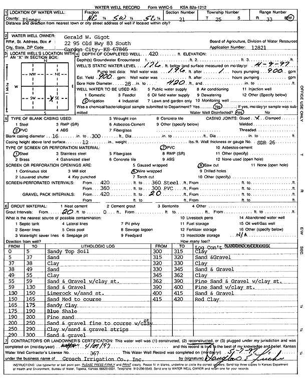
Specific Water Well Detail |
|
|
| Location Info | |||
| Owner: Gigot, Gerald W. | Status: Reconstructed | ||
| Location: T25S, R33W, Sec. 21, NE SW SE | County: Finney | ||
| Directions: | |||
| Latitude: 37.8613432 | Longitude: -100.9436823 | Datum NAD 27 | |
| Latitude: 37.8613669 | Longitude: -100.9441258 | Datum NAD 83 | |
| Longitude and latitude calculated by Survey from township-range-section-quarter calls. Only good to within the quarter call accuracy. | |||
| View well on interactive map | |||
| General Info | ||
| Well Depth: 420 ft. | Elevation: ft. | |
| Static Water Level: 176 ft. | Est. Yield: 900 gpm. | |
| Comp. Date: 07-Apr-1997 | Well Use: Irrigation | |
| DWR Applic. #: 12821 | Other ID: | |
| Links | |
| View info from Wizard Water Level Data base... | |
| View info from WIMAS Water Right Data base... | |
| Driller Info | ||
| Driller: Dick Grosch lrrigating Co., Inc. | License #: 367 | |
| Scanned Form | View scan |
|
Chemical Sample Submitted?: No
Water Well disinfected?: | ||
| Ground water encountered: 0 ft. , 0 ft. , 0 ft. | ||
| Pump test data: Well water was 0 ft after 0 hours pumping 0 gpm | ||
| Casing Info | ||
| Casing Type: PVC
Casing Joints: |
Diam: 16 in. to 300 ft
Diam: 0 in. to 0 ft Diam: 0 in. to 0 ft | |
| Casing height above land surface: in
Casing Weight: lbs/ft Wall thickness or gauge no.: | ||
| Screen and Perforation Info | ||
| Screen Type: PVC | Screen Openings: Saw cut | |
| Screen-perforated intervals | From: 420 ft to 360 ft
From: 360 ft to 300 ft From: 0 ft to 0 ft | |
| Gravel pack intervals | From: ft to ft | |
| Grout Info | ||
| Grout used: Bentonite | From: 20 to 0 ft
From: 0 to 0 ft From: 0 to 0 ft | |
| Source of Possible Contamination | ||
| Source: | ||
| Direction from well: | Distance: 0 ft | |
| Lithologic Log
(Log data entered by KGS.) | ||
| From: 0 ft. to 5 ft. | sandy top soil | |
| From: 5 ft. to 37 ft. | sand | |
| From: 37 ft. to 38 ft. | clay | |
| From: 38 ft. to 49 ft. | sand | |
| From: 49 ft. to 55 ft. | clay | |
| From: 55 ft. to 59 ft. | sand and gravel with clay streaks | |
| From: 59 ft. to 130 ft. | sand and gravel | |
| From: 130 ft. to 150 ft. | lime rock with sand streaks | |
| From: 150 ft. to 165 ft. | sand, medium to coarse | |
| From: 165 ft. to 175 ft. | sandy clay | |
| From: 175 ft. to 190 ft. | blue shale | |
| From: 190 ft. to 200 ft. | fine sand | |
| From: 200 ft. to 250 ft. | fine to coarse sand and gravel with clay streaks | |
| From: 250 ft. to 290 ft. | clay with sand and gravel strips | |
| From: 290 ft. to 300 ft. | sand and gravel | |
| From: 300 ft. to 315 ft. | clay | |
| From: 315 ft. to 320 ft. | sand and gravel | |
| From: 320 ft. to 330 ft. | clay | |
| From: 330 ft. to 345 ft. | sand and gravel | |
| From: 345 ft. to 362 ft. | clay | |
| From: 362 ft. to 390 ft. | fine sand and gravel with clay streaks | |
| From: 390 ft. to 400 ft. | fine sand with clay streaks | |
| From: 400 ft. to 415 ft. | sand and gravel | |
| From: 415 ft. to 420 ft. | red clay | |