|
|
|
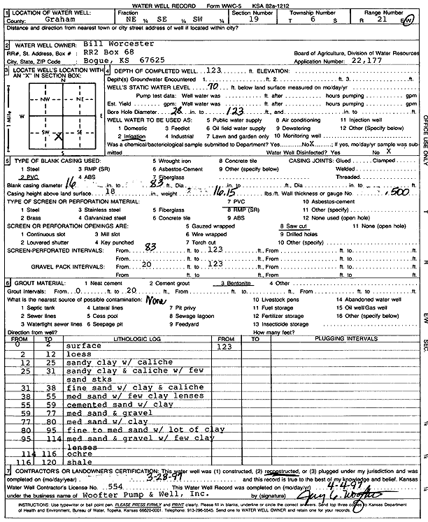
Specific Water Well Detail |
|
|
| Location Info | |||
| Owner: Worcester, Bill | Status: Reconstructed | ||
| Location: T6S, R21W, Sec. 19, NE SE SW | County: Graham | ||
| Directions: | |||
| Latitude: 39.5126967 | Longitude: -99.7048988 | Datum NAD 27 | |
| Latitude: 39.5127034 | Longitude: -99.7052907 | Datum NAD 83 | |
| Longitude and latitude calculated by Survey from township-range-section-quarter calls. Only good to within the quarter call accuracy. | |||
| View well on interactive map | |||
| General Info | ||
| Well Depth: 123 ft. | Elevation: ft. | |
| Static Water Level: 70 ft. | Est. Yield: gpm. | |
| Comp. Date: 28-Mar-1997 | Well Use: Irrigation | |
| DWR Applic. #: 22177 | Other ID: | |
| Links | |
| No Wizard information available. | |
| View info from WIMAS Water Right Data base... | |
| Driller Info | ||
| Driller: Jay C. Woofter Pump & Well, Inc. | License #: 554 | |
| Scanned Form | View scan |
|
Chemical Sample Submitted?: No
Water Well disinfected?: | ||
| Ground water encountered: 0 ft. , 0 ft. , 0 ft. | ||
| Pump test data: Well water was 0 ft after 0 hours pumping 0 gpm | ||
| Casing Info | ||
| Casing Type: PVC
Casing Joints: |
Diam: 16 in. to 83 ft
Diam: 0 in. to 0 ft Diam: 0 in. to 0 ft | |
| Casing height above land surface: in
Casing Weight: lbs/ft Wall thickness or gauge no.: | ||
| Screen and Perforation Info | ||
| Screen Type: PVC | Screen Openings: Saw cut | |
| Screen-perforated intervals | From: 83 ft to 123 ft
From: 0 ft to 0 ft From: 0 ft to 0 ft | |
| Gravel pack intervals | From: ft to ft | |
| Grout Info | ||
| Grout used: Bentonite | From: 0 to 20 ft
From: 0 to 0 ft From: 0 to 0 ft | |
| Source of Possible Contamination | ||
| Source: | ||
| Direction from well: | Distance: 0 ft | |
| Lithologic Log
(Log data entered by KGS.) | ||
| From: 0 ft. to 2 ft. | surface | |
| From: 2 ft. to 12 ft. | loess | |
| From: 12 ft. to 25 ft. | sandy clay with caliche | |
| From: 25 ft. to 31 ft. | sandy clay and caliche with few sand streaks | |
| From: 31 ft. to 38 ft. | fine sand with clay and caliche | |
| From: 38 ft. to 55 ft. | medium sand with few clay lenses | |
| From: 55 ft. to 59 ft. | cemented sand with clay | |
| From: 59 ft. to 77 ft. | medium sand and gravel | |
| From: 77 ft. to 80 ft. | medium sand with clay | |
| From: 80 ft. to 95 ft. | fine to medium sand with lots of clay | |
| From: 95 ft. to 114 ft. | medium sand and gravel with few clay lenses | |
| From: 114 ft. to 116 ft. | ochre | |
| From: 116 ft. to 120 ft. | shale | |