|
|
|
Specific Water Well Detail |
|
|
| Location Info | |||
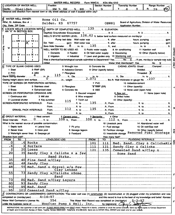
| Owner: Home Oil Company | Status: Constructed | ||
| Location: T6S, R29W, Sec. 9, NW SW NE | County: Sheridan | ||
| Directions: | |||
| Latitude: 39.5485859 | Longitude: -100.5606695 | Datum NAD 27 | |
| Latitude: 39.5485899 | Longitude: -100.5610913 | Datum NAD 83 | |
| Longitude and latitude calculated by Survey from township-range-section-quarter calls. Only good to within the quarter call accuracy. | |||
| View well on interactive map | |||
| General Info | ||
| Well Depth: 135 ft. | Elevation: ft. | |
| Static Water Level: 126.62 ft. | Est. Yield: gpm. | |
| Comp. Date: 14-Apr-1997 | Well Use: Monitoring well/observation/piezometer | |
| DWR Applic. #: | Other ID: OBW 1 | |
| Driller Info | ||
| Driller: Woofter Pump & Well, Inc. | License #: 554 | |
| Scanned Form | View scan |
|
Chemical Sample Submitted?: No
Water Well disinfected?: | ||
| Ground water encountered: 0 ft. , 0 ft. , 0 ft. | ||
| Pump test data: Well water was 0 ft after 0 hours pumping 0 gpm | ||
| Casing Info | ||
| Casing Type: PVC
Casing Joints: |
Diam: 4 in. to 115 ft
Diam: 0 in. to 0 ft Diam: 0 in. to 0 ft | |
| Casing height above land surface: in
Casing Weight: lbs/ft Wall thickness or gauge no.: | ||
| Screen and Perforation Info | ||
| Screen Type: PVC | Screen Openings: Saw cut | |
| Screen-perforated intervals | From: 115 ft to 135 ft
From: 0 ft to 0 ft From: 0 ft to 0 ft | |
| Gravel pack intervals | From: ft to ft | |
| Grout Info | ||
| Grout used: Cement grout, Bentonite | From: 0 to 108 ft
From: 108 to 112 ft From: 0 to 0 ft | |
| Source of Possible Contamination | ||
| Source: | ||
| Direction from well: | Distance: 0 ft | |
| Lithologic Log
(Log data entered by KGS.) | ||
| From: 0 ft. to .6 ft. | Rocks | |
| From: .6 ft. to 2 ft. | Surface | |
| From: 2 ft. to 20 ft. | Loess | |
| From: 20 ft. to 35 ft. | Sandy clay and caliche and a few sand streaks | |
| From: 35 ft. to 40 ft. | Fine sand with clay | |
| From: 40 ft. to 48 ft. | Sandy clay | |
| From: 48 ft. to 55 ft. | Medium sand and gravel with a few clay lenses | |
| From: 55 ft. to 73 ft. | Sandy clay with caliche and some sand | |
| From: 73 ft. to 80 ft. | Medium sand with clay layers | |
| From: 80 ft. to 93 ft. | Sandy clay | |
| From: 93 ft. to 95 ft. | Medium sand | |
| From: 95 ft. to 101 ft. | Cemented sand with clay | |
| From: 101 ft. to 111 ft. | Medium sand, clay and caliche mix | |
| From: 111 ft. to 121 ft. | Sandy clay and caliche | |
| From: 121 ft. to 135 ft. | Cemented sand with clay and some sand | |