|
|
|
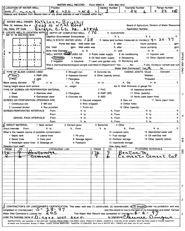
Specific Water Well Detail |
|
|
| Location Info | |||
| Owner: Bruchy, Kathleen | Status: Plugged | ||
| Location: T24S, R33W, Sec. 2, NE SE NE | County: Finney | ||
| Directions: | |||
| Latitude: 37.9994332 | Longitude: -100.90251 | Datum NAD 27 | |
| Latitude: 37.9994565 | Longitude: -100.9029505 | Datum NAD 83 | |
| Longitude and latitude calculated by Survey from township-range-section-quarter calls. Only good to within the quarter call accuracy. | |||
| View well on interactive map | |||
| General Info | ||
| Well Depth: 176 ft. | Elevation: ft. | |
| Static Water Level: 128 ft. | Est. Yield: gpm. | |
| Comp. Date: 28-May-1997 | Well Use: Domestic | |
| DWR Applic. #: | Other ID: | |
| Driller Info | ||
| Driller: Clarence L. Dingus Well Service & Trenching | License #: 205 | |
| Scanned Form | View scan |
| Casing Info | ||
|
Casing Type: Steel
Diam: 4 in. Casing height above land surface: in | ||
| Grout Info | ||
| Grout used: Cement grout, Bentonite | From: 9 to 6 ft
From: 9 to 176 ft From: 0 to 0 ft | |
| Source of Possible Contamination | ||
| Source: | ||
| Direction from well: | Distance: 0 ft | |