|
|
|
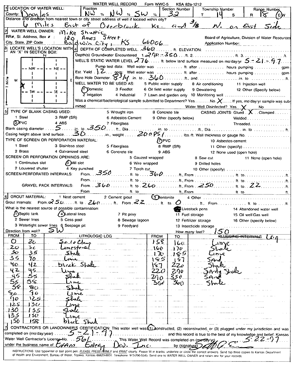
Specific Water Well Detail |
|
|
| Location Info | |||
| Owner: Shuttic, Mike | Status: Constructed | ||
| Location: T14S, R18E, Sec. 32, NW NW SW | County: Douglas | ||
| Directions: from Overbrook: 6 mi E, .38 mi N, E side | |||
| Latitude: 38.7888027 | Longitude: -95.4447942 | Datum NAD 27 | |
| Latitude: 38.788808 | Longitude: -95.4450498 | Datum NAD 83 | |
| Longitude and latitude calculated by Survey from township-range-section-quarter calls. Only good to within the quarter call accuracy. | |||
| View well on interactive map | |||
| General Info | ||
| Well Depth: 360 ft. | Elevation: ft. | |
| Static Water Level: 276 ft. | Est. Yield: gpm. | |
| Comp. Date: 21-May-1997 | Well Use: Domestic | |
| DWR Applic. #: | Other ID: | |
| Driller Info | ||
| Driller: Evans Energy Development, Inc. | License #: 561 | |
| Scanned Form | View scan |
|
Chemical Sample Submitted?: No
Water Well disinfected?: | ||
| Ground water encountered: 290 ft. , 350 ft. , 0 ft. | ||
| Pump test data: Well water was 0 ft after 0 hours pumping 0 gpm | ||
| Casing Info | ||
| Casing Type: PVC
Casing Joints: |
Diam: 5 in. to 350 ft
Diam: 0 in. to 0 ft Diam: 0 in. to 0 ft | |
| Casing height above land surface: in
Casing Weight: lbs/ft Wall thickness or gauge no.: | ||
| Screen and Perforation Info | ||
| Screen Type: PVC | Screen Openings: Mill slot | |
| Screen-perforated intervals | From: 350 ft to 360 ft
From: 0 ft to 0 ft From: 0 ft to 0 ft | |
| Gravel pack intervals | From: ft to ft | |
| Grout Info | ||
| Grout used: Bentonite | From: 256 to 260 ft
From: 22 to 0 ft From: 0 to 0 ft | |
| Source of Possible Contamination | ||
| Source: Septic Tank | ||
| Direction from well: SW | Distance: 150 ft | |
| Lithologic Log
(Log data entered by KGS.) | ||
| From: 0 ft. to 20 ft. | Soil and clay | |
| From: 20 ft. to 30 ft. | Limestone | |
| From: 30 ft. to 35 ft. | Shale | |
| From: 35 ft. to 40 ft. | Lime | |
| From: 40 ft. to 42 ft. | Black shale | |
| From: 42 ft. to 45 ft. | Lime | |
| From: 45 ft. to 55 ft. | Shale | |
| From: 55 ft. to 58 ft. | Lime | |
| From: 58 ft. to 80 ft. | Shale | |
| From: 80 ft. to 90 ft. | Lime | |
| From: 90 ft. to 125 ft. | Shale | |
| From: 125 ft. to 130 ft. | Lime | |
| From: 130 ft. to 135 ft. | Shale | |
| From: 135 ft. to 150 ft. | Lime | |
| From: 150 ft. to 158 ft. | Black shale | |
| From: 158 ft. to 160 ft. | Lime | |
| From: 160 ft. to 170 ft. | Shale | |
| From: 170 ft. to 185 ft. | Lime | |
| From: 185 ft. to 187 ft. | Sand | |
| From: 187 ft. to 220 ft. | Shale | |
| From: 220 ft. to 290 ft. | Sandy shale | |
| From: 290 ft. to 350 ft. | Sand | |
| From: 350 ft. to 360 ft. | Shale | |