|
|
|
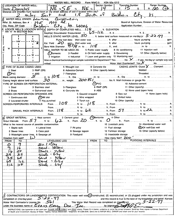
Specific Water Well Detail |
|
|
| Location Info | |||
| Owner: Lawrenz Construction | Status: Constructed | ||
| Location: T15S, R20E, Sec. 14, NE SE NE | County: Douglas | ||
| Directions: from Baldwin City: 2 mi E, 1.8 mi S | |||
| Latitude: 38.7485245 | Longitude: -95.1497433 | Datum NAD 27 | |
| Latitude: 38.7485324 | Longitude: -95.1499916 | Datum NAD 83 | |
| Longitude and latitude calculated by Survey from township-range-section-quarter calls. Only good to within the quarter call accuracy. | |||
| View well on interactive map | |||
| General Info | ||
| Well Depth: 118 ft. | Elevation: ft. | |
| Static Water Level: 50 ft. | Est. Yield: 20 gpm. | |
| Comp. Date: 22-May-1997 | Well Use: Domestic | |
| DWR Applic. #: | Other ID: | |
| Driller Info | ||
| Driller: Evans Energy Development, Inc. | License #: 561 | |
| Scanned Form | View scan |
|
Chemical Sample Submitted?: No
Water Well disinfected?: | ||
| Ground water encountered: 65 ft. , 112 ft. , 0 ft. | ||
| Pump test data: Well water was 0 ft after 0 hours pumping 0 gpm | ||
| Casing Info | ||
| Casing Type: PVC
Casing Joints: |
Diam: 5 in. to 108 ft
Diam: 0 in. to 0 ft Diam: 0 in. to 0 ft | |
| Casing height above land surface: in
Casing Weight: lbs/ft Wall thickness or gauge no.: | ||
| Screen and Perforation Info | ||
| Screen Type: PVC | Screen Openings: Mill slot | |
| Screen-perforated intervals | From: 108 ft to 118 ft
From: 0 ft to 0 ft From: 0 ft to 0 ft | |
| Gravel pack intervals | From: ft to ft | |
| Grout Info | ||
| Grout used: Bentonite | From: 57 to 62 ft
From: 20 to 0 ft From: 0 to 0 ft | |
| Source of Possible Contamination | ||
| Source: Oil well/gas well | ||
| Direction from well: W | Distance: 200 ft | |
| Lithologic Log
(Log data entered by KGS.) | ||
| From: 0 ft. to 9 ft. | soil and clay | |
| From: 9 ft. to 16 ft. | sand, yellow | |
| From: 16 ft. to 29 ft. | shale, yellow | |
| From: 29 ft. to 35 ft. | shale, gray | |
| From: 35 ft. to 65 ft. | sand, yellow | |
| From: 65 ft. to 112 ft. | sand, gray | |
| From: 112 ft. to 118 ft. | shale, gray | |