|
|
|
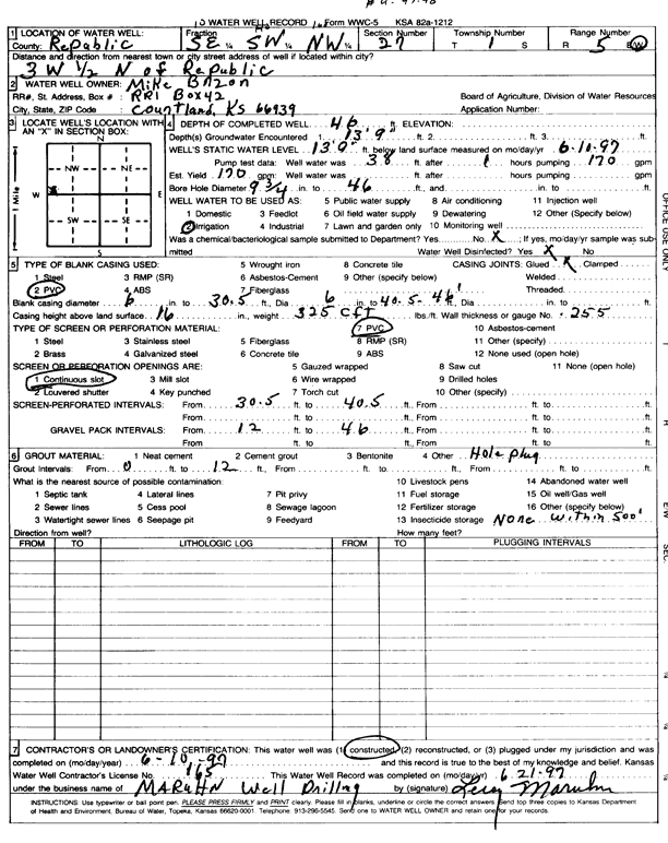
Specific Water Well Detail |
|
|
| Location Info | |||
| Owner: Brzon, Mike | Status: Constructed | ||
| Location: T1S, R5W, Sec. 27, SE SW NW | County: Republic | ||
| Directions: from Republic, 3 mi W and 0.5 mi N | |||
| Latitude: 39.9372368 | Longitude: -97.8723873 | Datum NAD 27 | |
| Latitude: 39.937248 | Longitude: -97.8727083 | Datum NAD 83 | |
| Longitude and latitude calculated by Survey from township-range-section-quarter calls. Only good to within the quarter call accuracy. | |||
| View well on interactive map | |||
| General Info | ||
| Well Depth: 46 ft. | Elevation: ft. | |
| Static Water Level: 13.75 ft. | Est. Yield: 170 gpm. | |
| Comp. Date: 10-Jun-1997 | Well Use: Irrigation | |
| DWR Applic. #: | Other ID: | |
| Links | |
| No Wizard information available. | |
| View info from WIMAS Water Right Data base... | |
| Driller Info | ||
| Driller: Leroy Maruhn Well Drilling, Inc. | License #: 165 | |
| Scanned Form | View scan |
|
Chemical Sample Submitted?: No
Water Well disinfected?: | ||
| Ground water encountered: 13.9 ft. , 0 ft. , 0 ft. | ||
| Pump test data: Well water was 0 ft after 0 hours pumping 0 gpm | ||
| Casing Info | ||
| Casing Type: PVC
Casing Joints: |
Diam: 6 in. to 30.5 ft
Diam: 6 in. to 46 ft Diam: 0 in. to 0 ft | |
| Casing height above land surface: in
Casing Weight: lbs/ft Wall thickness or gauge no.: | ||
| Screen and Perforation Info | ||
| Screen Type: PVC | Screen Openings: Continuous slot | |
| Screen-perforated intervals | From: 30.5 ft to 40.5 ft
From: 0 ft to 0 ft From: 0 ft to 0 ft | |
| Gravel pack intervals | From: ft to ft | |
| Grout Info | ||
| Grout used: | From: 0 to 12 ft
From: 0 to 0 ft From: 0 to 0 ft | |
| Source of Possible Contamination | ||
| Source: | ||
| Direction from well: | Distance: 0 ft | |