|
|
|
Specific Water Well Detail |
|
|
| Location Info | |||
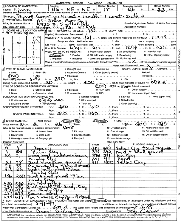
| Owner: Tri Stone Farms | Status: Constructed | ||
| Location: T26S, R33W, Sec. 18, NE NE NE | County: Finney | ||
| Directions: from Plymell corner: 4 mi W, 1 mi S, 1 mi W, and S into site | |||
| Latitude: 37.7939867 | Longitude: -100.9627794 | Datum NAD 27 | |
| Latitude: 37.7940104 | Longitude: -100.9632243 | Datum NAD 83 | |
| Longitude and latitude calculated by Survey from township-range-section-quarter calls. Only good to within the quarter call accuracy. | |||
| View well on interactive map | |||
| General Info | ||
| Well Depth: 410 ft. | Elevation: ft. | |
| Static Water Level: 161 ft. | Est. Yield: gpm. | |
| Comp. Date: 11-Aug-1997 | Well Use: Domestic | |
| DWR Applic. #: | Other ID: | |
| Driller Info | ||
| Driller: Cramer Drilling Co. | License #: 600 | |
| Scanned Form | View scan |
|
Chemical Sample Submitted?: No
Water Well disinfected?: | ||
| Ground water encountered: 0 ft. , 0 ft. , 0 ft. | ||
| Pump test data: Well water was 0 ft after 0 hours pumping 0 gpm | ||
| Casing Info | ||
| Casing Type: PVC
Casing Joints: |
Diam: 6.5 in. to 350 ft
Diam: 0 in. to 0 ft Diam: 0 in. to 0 ft | |
| Casing height above land surface: in
Casing Weight: lbs/ft Wall thickness or gauge no.: | ||
| Screen and Perforation Info | ||
| Screen Type: PVC | Screen Openings: Mill slot | |
| Screen-perforated intervals | From: 350 ft to 410 ft
From: 0 ft to 0 ft From: 0 ft to 0 ft | |
| Gravel pack intervals | From: ft to ft | |
| Grout Info | ||
| Grout used: Cement grout, Bentonite | From: 2 to 26 ft
From: 200 to 310 ft From: 0 to 0 ft | |
| Source of Possible Contamination | ||
| Source: | ||
| Direction from well: | Distance: 0 ft | |
| Lithologic Log
(Log data entered by KGS.) | ||
| From: 0 ft. to 4 ft. | topsoil | |
| From: 4 ft. to 23 ft. | brown clay | |
| From: 23 ft. to 51 ft. | coarse sand, sandstone and brown sandy clay | |
| From: 51 ft. to 78 ft. | sand and medium gravel | |
| From: 78 ft. to 93 ft. | tan sandy clay with gravel streaks | |
| From: 93 ft. to 156 ft. | sand and small gravel with brown sandy clay | |
| From: 156 ft. to 230 ft. | sand and small gravel with tan sandy clay | |
| From: 230 ft. to 243 ft. | tan sandy clay | |
| From: 243 ft. to 270 ft. | sand gravel with tan sandy clay | |
| From: 270 ft. to 287 ft. | tan sandy clay | |
| From: 287 ft. to 299 ft. | coarse sand | |
| From: 299 ft. to 314 ft. | tan and white clay with gravel streaks | |
| From: 314 ft. to 349 ft. | yellow clay with sand streaks | |
| From: 349 ft. to 372 ft. | sand and small gravel | |
| From: 372 ft. to 391 ft. | tan clay | |
| From: 391 ft. to 411 ft. | sand | |
| From: 411 ft. to 420 ft. | yellow clay | |