|
|
|
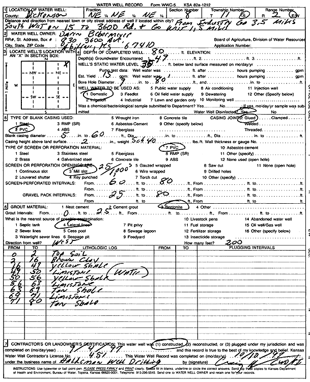
Specific Water Well Detail |
|
|
| Location Info | |||
| Owner: Bebermeyer, Darin | Status: Constructed | ||
| Location: T11S, R2E, Sec. 8, NE NE NE | County: Dickinson | ||
| Directions: from Industry, 3.5 mi SW on K-15 to 3600 Rd, 1.5 mi W | |||
| Latitude: 39.1180538 | Longitude: -97.224007 | Datum NAD 27 | |
| Latitude: 39.1180497 | Longitude: -97.224306 | Datum NAD 83 | |
| Longitude and latitude calculated by Survey from township-range-section-quarter calls. Only good to within the quarter call accuracy. | |||
| View well on interactive map | |||
| General Info | ||
| Well Depth: 80 ft. | Elevation: ft. | |
| Static Water Level: 35 ft. | Est. Yield: 15 gpm. | |
| Comp. Date: 04-Sep-1997 | Well Use: Domestic | |
| DWR Applic. #: | Other ID: | |
| Driller Info | ||
| Driller: Haldeman Well Drilling & Pump Service | License #: 451 | |
| Scanned Form | View scan |
|
Chemical Sample Submitted?: No
Water Well disinfected?: | ||
| Ground water encountered: 49 ft. , 0 ft. , 0 ft. | ||
| Pump test data: Well water was 0 ft after 0 hours pumping 0 gpm | ||
| Casing Info | ||
| Casing Type: PVC
Casing Joints: |
Diam: 5 in. to 60 ft
Diam: 0 in. to 0 ft Diam: 0 in. to 0 ft | |
| Casing height above land surface: in
Casing Weight: lbs/ft Wall thickness or gauge no.: | ||
| Screen and Perforation Info | ||
| Screen Type: PVC | Screen Openings: Mill slot | |
| Screen-perforated intervals | From: 60 ft to 80 ft
From: 0 ft to 0 ft From: 0 ft to 0 ft | |
| Gravel pack intervals | From: ft to ft | |
| Grout Info | ||
| Grout used: Bentonite | From: 0 to 25 ft
From: 0 to 0 ft From: 0 to 0 ft | |
| Source of Possible Contamination | ||
| Source: Lateral lines | ||
| Direction from well: W | Distance: 200 ft | |
| Lithologic Log
(Log data entered by KGS.) | ||
| From: 0 ft. to 2 ft. | top soil | |
| From: 2 ft. to 16 ft. | brown clay | |
| From: 16 ft. to 49 ft. | yellow shale | |
| From: 49 ft. to 50 ft. | limestone | |
| From: 50 ft. to 56 ft. | yellow shale | |
| From: 56 ft. to 63 ft. | limestone | |
| From: 63 ft. to 69 ft. | tan shale | |
| From: 69 ft. to 71 ft. | limestone | |
| From: 71 ft. to 80 ft. | tan shale | |