|
|
|
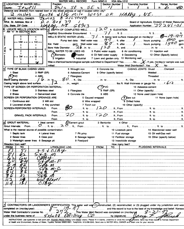
Specific Water Well Detail |
|
|
| Location Info | |||
| Owner: Zoltenko, James | Status: Constructed | ||
| Location: T1S, R6W, Sec. 11, SW SE SE | County: Jewell | ||
| Directions: from Hardy, NE, 2 mi S and 1.25 mi W | |||
| Latitude: 39.9729988 | Longitude: -97.9542017 | Datum NAD 27 | |
| Latitude: 39.9730118 | Longitude: -97.9545228 | Datum NAD 83 | |
| Longitude and latitude calculated by Survey from township-range-section-quarter calls. Only good to within the quarter call accuracy. | |||
| View well on interactive map | |||
| General Info | ||
| Well Depth: 120 ft. | Elevation: ft. | |
| Static Water Level: 71 ft. | Est. Yield: gpm. | |
| Comp. Date: 19-Aug-1997 | Well Use: Domestic | |
| DWR Applic. #: 37241-01 | Other ID: | |
| Driller Info | ||
| Driller: Dale Shuck Drilling Co. | License #: 272 | |
| Scanned Form | View scan |
|
Chemical Sample Submitted?: No
Water Well disinfected?: | ||
| Ground water encountered: 71 ft. , 0 ft. , 0 ft. | ||
| Pump test data: Well water was 0 ft after 0 hours pumping 0 gpm | ||
| Casing Info | ||
| Casing Type: PVC
Casing Joints: |
Diam: 16 in. to 80 ft
Diam: 0 in. to 0 ft Diam: 0 in. to 0 ft | |
| Casing height above land surface: in
Casing Weight: lbs/ft Wall thickness or gauge no.: | ||
| Screen and Perforation Info | ||
| Screen Type: PVC | Screen Openings: Saw cut | |
| Screen-perforated intervals | From: 80 ft to 120 ft
From: 0 ft to 0 ft From: 0 ft to 0 ft | |
| Gravel pack intervals | From: ft to ft | |
| Grout Info | ||
| Grout used: Cement grout | From: 0 to 20 ft
From: 0 to 0 ft From: 0 to 0 ft | |
| Source of Possible Contamination | ||
| Source: | ||
| Direction from well: | Distance: 0 ft | |
| Lithologic Log
(Log data entered by KGS.) | ||
| From: 0 ft. to 51 ft. | top soil and clay | |
| From: 51 ft. to 62 ft. | sand and gravel, medium | |
| From: 62 ft. to 64 ft. | clay | |
| From: 64 ft. to 69 ft. | sand and gravel, medium-fine | |
| From: 69 ft. to 82 ft. | sand and gravel, medium | |
| From: 82 ft. to 84 ft. | sand and gravel, medium-coarse | |
| From: 84 ft. to 86 ft. | sand and gravel, fine | |
| From: 86 ft. to 112 ft. | sand and gravel, medium | |
| From: 112 ft. to 119 ft. | white wheat gravel | |
| From: 119 ft. to 121 ft. | clay | |