|
|
|
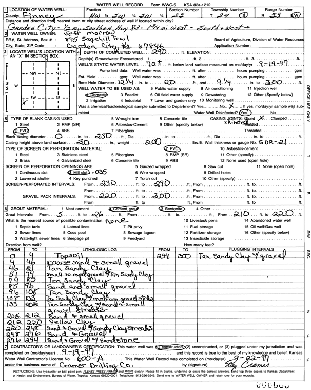
Specific Water Well Detail |
|
|
| Location Info | |||
| Owner: Morrow, Jeff | Status: Constructed | ||
| Location: T24S, R33W, Sec. 23, NW SW SW | County: Finney | ||
| Directions: .5 mi S on HWY 83, 1.75 mi W, S and W into location | |||
| Latitude: 37.9487314 | Longitude: -100.9184522 | Datum NAD 27 | |
| Latitude: 37.948755 | Longitude: -100.918894 | Datum NAD 83 | |
| Longitude and latitude calculated by Survey from township-range-section-quarter calls. Only good to within the quarter call accuracy. | |||
| View well on interactive map | |||
| General Info | ||
| Well Depth: 290 ft. | Elevation: ft. | |
| Static Water Level: 70 ft. | Est. Yield: gpm. | |
| Comp. Date: 19-Sep-1997 | Well Use: Domestic | |
| DWR Applic. #: | Other ID: | |
| Driller Info | ||
| Driller: Ray Cramer Drilling Co. | License #: 600 | |
| Scanned Form | View scan |
|
Chemical Sample Submitted?: No
Water Well disinfected?: | ||
| Ground water encountered: 0 ft. , 0 ft. , 0 ft. | ||
| Pump test data: Well water was 0 ft after 0 hours pumping 0 gpm | ||
| Casing Info | ||
| Casing Type: PVC
Casing Joints: |
Diam: 0 in. to 230 ft
Diam: 0 in. to 0 ft Diam: 0 in. to 0 ft | |
| Casing height above land surface: in
Casing Weight: lbs/ft Wall thickness or gauge no.: | ||
| Screen and Perforation Info | ||
| Screen Type: PVC | Screen Openings: Mill slot | |
| Screen-perforated intervals | From: 230 ft to 290 ft
From: 0 ft to 0 ft From: 0 ft to 0 ft | |
| Gravel pack intervals | From: ft to ft | |
| Grout Info | ||
| Grout used: Cement grout, Bentonite | From: 5 to 26 ft
From: 210 to 220 ft From: 0 to 0 ft | |
| Source of Possible Contamination | ||
| Source: | ||
| Direction from well: | Distance: 0 ft | |
| Lithologic Log
(Log data entered by KGS.) | ||
| From: 0 ft. to 4 ft. | topsoil | |
| From: 4 ft. to 46 ft. | coarse sand and small gravel | |
| From: 46 ft. to 51 ft. | tan sandy clay | |
| From: 51 ft. to 74 ft. | small to med gravel and tan sandy clay | |
| From: 74 ft. to 85 ft. | tan sandy clay | |
| From: 85 ft. to 96 ft. | sand and small gravel | |
| From: 96 ft. to 108 ft. | tan sandy clay | |
| From: 108 ft. to 133 ft. | tan sandy clay with medium gravel streaks | |
| From: 133 ft. to 205 ft. | tan sandy clay with sand and small gravel streaks | |
| From: 205 ft. to 212 ft. | sand and small gravel | |
| From: 212 ft. to 220 ft. | yellow clay | |
| From: 220 ft. to 248 ft. | sand and gravel with sandy clay streaks | |
| From: 248 ft. to 276 ft. | sand and gravel | |
| From: 276 ft. to 294 ft. | sand and gravel with sandstone | |
| From: 294 ft. to 300 ft. | tan sandy clay with gravel | |