|
|
|
Specific Water Well Detail |
|
|
| Location Info | |||
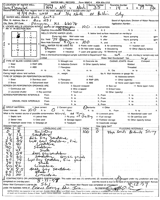
| Owner: Lantis, Gale | Status: Plugged | ||
| Location: T14S, R19E, Sec. 35, NW NE NW | County: Douglas | ||
| Directions: from Baldwin City: 4.75 mi W, .75 mi N | |||
| Latitude: 38.7960248 | Longitude: -95.2729248 | Datum NAD 27 | |
| Latitude: 38.7960309 | Longitude: -95.2731762 | Datum NAD 83 | |
| Longitude and latitude calculated by Survey from township-range-section-quarter calls. Only good to within the quarter call accuracy. | |||
| View well on interactive map | |||
| General Info | ||
| Well Depth: 100 ft. | Elevation: ft. | |
| Static Water Level: ft. | Est. Yield: gpm. | |
| Comp. Date: 11-Aug-1997 | Well Use: Domestic | |
| DWR Applic. #: | Other ID: | |
| Driller Info | ||
| Driller: Evans Energy Development, Inc. | License #: 561 | |
| Scanned Form | View scan |
| Casing Info | ||
|
Casing Type: OTHER
Diam: 2 in. Casing height above land surface: in | ||
| Grout Info | ||
| Grout used: Bentonite | From: 100 to 0 ft
From: 0 to 0 ft From: 0 to 0 ft | |
| Source of Possible Contamination | ||
| Source: | ||
| Direction from well: | Distance: 0 ft | |
| Lithologic Log
(Log data entered by KGS.) | ||
| From: 0 ft. to 8 ft. | soil and clay | |
| From: 8 ft. to 12 ft. | sandstone | |
| From: 12 ft. to 25 ft. | dark gray sandstone | |
| From: 25 ft. to 38 ft. | light gray fine sandstone | |
| From: 38 ft. to 40 ft. | limestone | |
| From: 40 ft. to 41 ft. | sandstone | |
| From: 41 ft. to 43 ft. | shale | |
| From: 43 ft. to 58 ft. | dark gray sandstone | |
| From: 58 ft. to 60 ft. | coarse sandstone | |
| From: 60 ft. to 78 ft. | light gray fine sandstone | |
| From: 78 ft. to 80 ft. | shale | |
| From: 80 ft. to 82 ft. | limestone | |
| From: 82 ft. to 85 ft. | dark gray sandstone | |
| From: 85 ft. to 90 ft. | shale | |
| From: 90 ft. to 100 ft. | limestone | |