|
|
|
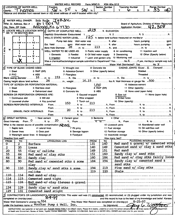
Specific Water Well Detail |
|
|
| Location Info | |||
| Owner: J and B Inc. | Status: Constructed | ||
| Location: T6S, R33W, Sec. 2, SW SE SW | County: Thomas | ||
| Directions: | |||
| Latitude: 39.5547186 | Longitude: -100.9734319 | Datum NAD 27 | |
| Latitude: 39.5547214 | Longitude: -100.9738639 | Datum NAD 83 | |
| Longitude and latitude calculated by Survey from township-range-section-quarter calls. Only good to within the quarter call accuracy. | |||
| View well on interactive map | |||
| General Info | ||
| Well Depth: 213 ft. | Elevation: ft. | |
| Static Water Level: 125 ft. | Est. Yield: gpm. | |
| Comp. Date: 04-Aug-1997 | Well Use: Irrigation | |
| DWR Applic. #: 42308 | Other ID: | |
| Links | |
| No Wizard information available. | |
| View info from WIMAS Water Right Data base... | |
| Driller Info | ||
| Driller: Jay C. Woofter Pump & Well, Inc. | License #: 554 | |
| Scanned Form | View scan |
|
Chemical Sample Submitted?: No
Water Well disinfected?: | ||
| Ground water encountered: 0 ft. , 0 ft. , 0 ft. | ||
| Pump test data: Well water was 0 ft after 0 hours pumping 0 gpm | ||
| Casing Info | ||
| Casing Type: PVC
Casing Joints: |
Diam: 16 in. to 153 ft
Diam: 0 in. to 0 ft Diam: 0 in. to 0 ft | |
| Casing height above land surface: in
Casing Weight: lbs/ft Wall thickness or gauge no.: | ||
| Screen and Perforation Info | ||
| Screen Type: PVC | Screen Openings: Saw cut | |
| Screen-perforated intervals | From: 153 ft to 213 ft
From: 0 ft to 0 ft From: 0 ft to 0 ft | |
| Gravel pack intervals | From: ft to ft | |
| Grout Info | ||
| Grout used: Bentonite | From: 0 to 20 ft
From: 0 to 0 ft From: 0 to 0 ft | |
| Source of Possible Contamination | ||
| Source: | ||
| Direction from well: | Distance: 0 ft | |
| Lithologic Log
(Log data entered by KGS.) | ||
| From: 0 ft. to 2 ft. | Surface | |
| From: 2 ft. to 20 ft. | Loess | |
| From: 20 ft. to 55 ft. | Clay with caliche | |
| From: 55 ft. to 64 ft. | Medium sand with clay streaks | |
| From: 64 ft. to 80 ft. | Sandy clay | |
| From: 80 ft. to 90 ft. | Medium sand with cemented streaks and some clay | |
| From: 90 ft. to 110 ft. | Sandy clay with sand streaks and some caliche | |
| From: 110 ft. to 114 ft. | Medium sand with clay | |
| From: 114 ft. to 115 ft. | Cemented sand tight | |
| From: 115 ft. to 124 ft. | Medium sand with clay lenses and gravel, loose | |
| From: 124 ft. to 129 ft. | Sandy clay with sand streaks | |
| From: 129 ft. to 131 ft. | Cemented sand, tight | |
| From: 131 ft. to 140 ft. | Medium sand and gravel with cemented streaks | |
| From: 140 ft. to 149 ft. | Cemented sand with clay and sand streaks | |
| From: 149 ft. to 151 ft. | Medium sand | |
| From: 151 ft. to 160 ft. | Sandy clay with sand streaks | |
| From: 160 ft. to 184 ft. | Medium sand with clay streaks fairly loose | |
| From: 184 ft. to 194 ft. | Sandy clay with cemented sand and sand streaks | |
| From: 194 ft. to 219 ft. | Fine sand with clay streaks | |
| From: 219 ft. to 220 ft. | Shale | |