|
|
|
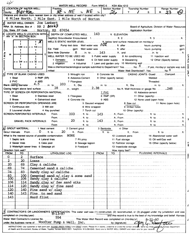
Specific Water Well Detail |
|
|
| Location Info | |||
| Owner: Lambert, Joe | Status: Constructed | ||
| Location: T1S, R23W, Sec. 26, NE NE NE | County: Norton | ||
| Directions: from Norton, 6 mi N, 1 mi E, and 1 mi N | |||
| Latitude: 39.9425914 | Longitude: -99.8706444 | Datum NAD 27 | |
| Latitude: 39.9425978 | Longitude: -99.8710437 | Datum NAD 83 | |
| Longitude and latitude calculated by Survey from township-range-section-quarter calls. Only good to within the quarter call accuracy. | |||
| View well on interactive map | |||
| General Info | ||
| Well Depth: 143 ft. | Elevation: ft. | |
| Static Water Level: ft. | Est. Yield: gpm. | |
| Comp. Date: 13-Aug-1997 | Well Use: Domestic | |
| DWR Applic. #: | Other ID: | |
| Driller Info | ||
| Driller: Jay C. Woofter Pump & Well, Inc. | License #: 554 | |
| Scanned Form | View scan |
|
Chemical Sample Submitted?: No
Water Well disinfected?: | ||
| Ground water encountered: 0 ft. , 0 ft. , 0 ft. | ||
| Pump test data: Well water was 0 ft after 0 hours pumping 0 gpm | ||
| Casing Info | ||
| Casing Type: PVC
Casing Joints: |
Diam: 4.5 in. to 103 ft
Diam: 0 in. to 0 ft Diam: 0 in. to 0 ft | |
| Casing height above land surface: in
Casing Weight: lbs/ft Wall thickness or gauge no.: | ||
| Screen and Perforation Info | ||
| Screen Type: PVC | Screen Openings: Saw cut | |
| Screen-perforated intervals | From: 103 ft to 143 ft
From: 0 ft to 0 ft From: 0 ft to 0 ft | |
| Gravel pack intervals | From: ft to ft | |
| Grout Info | ||
| Grout used: Bentonite | From: 0 to 20 ft
From: 0 to 0 ft From: 0 to 0 ft | |
| Source of Possible Contamination | ||
| Source: | ||
| Direction from well: | Distance: 0 ft | |
| Lithologic Log
(Log data entered by KGS.) | ||
| From: 0 ft. to 2 ft. | surface | |
| From: 2 ft. to 20 ft. | loess | |
| From: 20 ft. to 69 ft. | clay and caliche | |
| From: 69 ft. to 74 ft. | cemented sand and caliche | |
| From: 74 ft. to 83 ft. | sandy clay and caliche | |
| From: 83 ft. to 100 ft. | cemented sand with clay and some sand | |
| From: 100 ft. to 106 ft. | sandy clay and caliche | |
| From: 106 ft. to 114 ft. | sandy clay with few sand streaks | |
| From: 114 ft. to 120 ft. | sandy clay with fine sand | |
| From: 120 ft. to 140 ft. | fine sand with clay | |
| From: 140 ft. to 143 ft. | fine to medium sand | |
| From: 143 ft. to ft. | hard flint | |